
October 02, 2015
UPDATE: 5:30 p.m., Friday
The extremely dangerous Hurricane Joaquin will forgo a direct hit on us, but the massive buzzsaw which has devastated the Central Bahamas is now moving slowly north and will pass well east of the New Jersey shore early Monday morning .
Winds have dropped back to Cat 3 force – around 125mph – and will continue to weaken slightly by Sunday as the storm encounters much cooler waters and shearing of its environment. Still, its huge circulation will continue to sweep copious amounts of rain through the region tonight and most of Saturday.
The BIG impact will be along the shore points as major tidal flooding will occur during each high tide cycle right through Monday. Winds just offshore will gust to 60 mph and storm warnings have been hoisted offshore. The wind, combined with crashing wave heights of 6-12 feet, will produce extensive beach erosion. Windswept cold rains will add insult to misery.
Think of Joaquin as a 3-4 day Nor'easter, meaning Mother Nature will take a big bite of beach from the shore and spit it back out to sea.
The rains will slowly ease during the day on Saturday and we might actually dry out some on Sunday as winds continue to gust.
Just feel fortunate that we dodged what could have been a fate close to Sandy's magnitude.
As I've been saying for years – this is the new wave of extreme weather that will last for generations to come.
EAGLES FORECAST
FedExField, Landover, Md.
Game on! Windy, with threat of showers, high of 57-62.
• • •
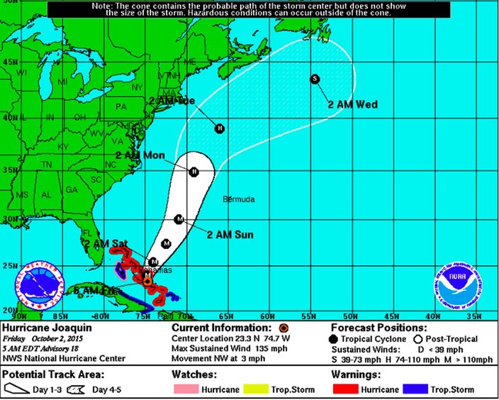
The "Beast in the East" – Hurricane Joaquin – continues to expand in size as the extremely dangerous Cat 4 hurricane continues to whip the Bahamas.
Its agonizing crawl toward the East Coast should slowly turn more north and then northeastward away from the coast.
RELATED STORY: NJ Governor Chris Christie urges residents to be prepared
The forecasted turn away from the coast should start today, however, due to the size and intensity of the storm, heavy rains and significant-to-major coastal flooding will spread north today, from the Mid-Atlantic region where 8-12 inches of flooding rain is anticipated.
Parts of the Philadelphia area, and especially the shores of Southern New Jersey and Delaware, will see 3-5 inches of rain, especially tonight into Saturday, along with moderate to perhaps some isolated major coastal flooding
The escape path I wrote about yesterday – a weakness in the High Pressure ridge – is becoming more evident and this should be the impetus that pushes the extremely dangerous Joaquin out to sea. It looks like by Monday Hurricane Joaquin should pass well east of the New Jersey shore and pass east of Montauk, New York on Tuesday, sparing the entire East Coast what could have been a disastrous strike.
On a technical note, the European model was the ONLY forecasting model to nail the forecast ... So far, "Hail to Euro."
Meanwhile, residents of the East Coast – from the Mid-Atlantic to the Northeast – still need to pay close attention just in case the "Beast in the East" decides to misbehave.
• • •
The National Weather Service forecasts for Philadelphia and the Jersey Shore:
Philadelphia
Friday: Periods of rain, heavy at times. High near 56. Breezy, with a northeast wind 18 to 20 mph. Chance of precipitation is 100 percent.
Friday night: Periods of rain, heavy at times. Low around 50. Breezy, with a northeast wind around 22 mph. Chance of precipitation is 90 percent.
Saturday: Rain or drizzle likely. Cloudy, with a high near 62. Breezy, with a northeast wind around 21 mph. Chance of precipitation is 60 percent.
Saturday night: Chance of light rain or drizzle. Cloudy, with a low around 60. Breezy. Chance of precipitation is 40 percent.
Sunday: Chance of rain. Cloudy, with a high near 68. Chance of precipitation is 40 percent.
Sunday night: Rain likely. Mostly cloudy, with a low around 61. Chance of precipitation is 30 percent.
Monday: Chance of showers. Mostly cloudy, with a high near 70. Chance of precipitation is 30 percent.
Monday night: Mostly cloudy, with a low around 57.
Jersey Shore
Friday: Periods of rain, heavy at times. High near 62. Windy, with a northeast wind around 30 mph, with gusts as high as 47 mph. Chance of precipitation is 100 percent.
Friday night: Periods of rain. Low around 59. Windy, with a northeast wind 29 to 31 mph, with gusts as high as 55 mph. Chance of precipitation is 100 percent.
Saturday: Rain or drizzle likely. Cloudy, with a high near 68. Windy, with a northeast wind around 30 mph, with gusts as high as 50 mph. Chance of precipitation is 70 percent.
Saturday night: Chance of rain or drizzle. Cloudy, with a low around 65. Windy. Chance of precipitation is 50 percent.
Sunday: Chance of rain. Cloudy, with a high near 69. Breezy. Chance of precipitation is 40 percent.
Sunday night: Chance of rain. Mostly cloudy, with a low around 64. Breezy. Chance of precipitation is 40 percent.
Monday: Chance of showers. Mostly cloudy, with a high near 70. Windy. Chance of precipitation is 40 percent.
Monday night: Mostly cloudy, with a low around 60.