


July 19, 2017
With a heat index expected to soar near 100 degrees on Thursday, the National Weather Service has issued an excessive heat warning.
The advisory, which runs from noon Thursday to 8 p.m. Friday, covers Philadelphia as well as Bucks, Chester, Delaware and Montgomery counties and South Jersey.
Real temperatures are forecast to rise into the middle 90s on both Thursday and Friday. Forecasters don't anticipate much relief at night with lows in the 70s. There's a slight chance of showers and thunderstorms on both nights, but any precipitation will do little to cool down the region.
Heat index values, which express the discomfort felt as a result of the combined effects of the temperature and humidity of the air, are expected to settle in the 98- to 103-degree range during the afternoon hours on both days, forecasters said.
The weather service advised those who work outside as well as the elderly and those with pre-existing health conditions to take precautions. It recommends:
• Drinking plenty of fluids
• Staying in an air-conditioned environment
• Staying out of the sun
• And checking on elderly relatives and neighbors.
In addition, it reminded that young children and pets should never be left unattended in a vehicle, especially during hot weather when a car`s interior can reach lethal temperatures in a matter of minutes.
The Delaware Valley Regional Planning Commission has issued a code orange air quality alert Thursday for the Philadelphia region. A code orange means that air pollution concentrations within the region may become unhealthy for sensitive groups, including children, those who suffer from asthma, heart disease or other lung diseases, and the elderly.
The National Weather Service is forecasting a heat index of near 100 for many parts of the region on Thursday.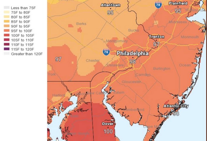 Source/National Weather Service
Here is the 7-day forecast for the Philadelphia area from the National Weather Service: