


October 29, 2017
Towns along the Jersey Shore will see heavy rains and damaging winds on Sunday night and into Monday morning.
The heaviest rain associated with the storm – a low-pressure system moving north from the North Carolina coast – is expected to fall in southern New Jersey and points north, with localized amounts of as much as 5 inches where the heaviest bands of rain set up, according to the National Weather Service.
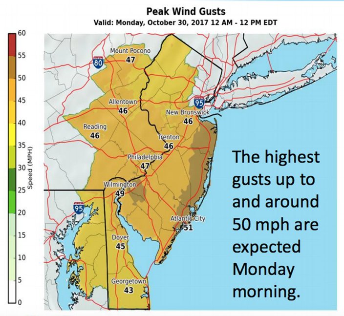
Wind gusts up to 50 mph are expected overnight and Monday morning along the Shore and a pocket of Salem County along the Delaware Bay.
The weather service has issued a flash flood watch for the entire Philadelphia region through midnight.
A wind advisory will be in effect from 2 a.m. to noon Monday. Winds out of the west at 20 to 30 mph and higher gusts will quickly increase overnight and peak during the early to mid-morning hours on Monday.
.
The rain will continue Sunday night, heavy at times, at least into the early evening. Rainfall amounts will generally be between 1 and 3 inches. But somewhere between the Delaware Valley and the Jersey Shore bands of locally heavy rain are expected to set up, forecasters said. Locations within these bands could see 3 to 5 inches of rain.
The weather service warned of rapidly rising water levels along streams and creeks and said poor drainage, common this time of year due to leaf debris, could worsen flooding. Localized roadway flooding is also possible.
Wind gusts will blow around objects that have not been secured, forecasters warned. Tree limbs could be blown down and a few power outages are possible.
A cold front is expected in the region Monday afternoon, followed by a stronger cold front on Monday night. Cold high pressure will move across the region Tuesday through Wednesday, and then offshore on Wednesday, forecasters said. A warm front will develop and pass through on Wednesday night. A cold front will slowly work its way across the region for the end of the week, followed by high pressure for at least part of the weekend, with more seasonal temperatures, before another frontal system may impact the area late in the weekend.
Here is the 7-day forecast for the Philadelphia region from the weather service:
Sunday afternoon: Showers, with rain heavy at times. High near 68. Southeast wind 11 to 13 mph. Chance of precipitation is 100 percent. New precipitation amounts between a quarter and half of an inch possible.
Sunday night: Showers, with rain heavy at times. Low around 47. East wind 9 to 11 mph becoming west after midnight. Chance of precipitation is 100 percent. New precipitation amounts between 1 and 2 inches possible.
Monday: Showers likely, mainly before 9 a.m. Cloudy through mid morning, then gradual clearing, with a high near 58. Breezy, with a west wind 21 to 23 mph. Chance of precipitation is 60 percent. New precipitation amounts of less than a tenth of an inch possible.
Monday night: Partly cloudy, with a low around 44. West wind 6 to 14 mph.
Tuesday: Mostly sunny, with a high near 60. West wind 5 to 15 mph.
Tuesday night: Partly cloudy, with a low around 42.
Wednesday: Mostly cloudy, with a high near 56.
Wednesday night: A chance of showers after 1 a.m. Mostly cloudy, with a low around 50. Chance of precipitation is 40 percent.
Thursday: A chance of showers. Mostly cloudy, with a high near 69. Chance of precipitation is 30 percent.
Thursday night: Mostly cloudy, with a low around 55.
Friday: Partly sunny, with a high near 71.
Friday night: Partly cloudy, with a low around 49.
Saturday: A chance of showers. Partly sunny, with a high near 60. Chance of precipitation is 30 percent.
Saturday night: A chance of showers. Mostly cloudy, with a low around 48. Chance of precipitation is 30 percent.
Sunday: A chance of showers. Mostly cloudy, with a high near 62.