


February 06, 2017
Near-record-high temperatures on Wednesday will be followed quickly by a potentially significant snowstorm that looks to drop the highest accumulations of the winter season so far.
And over the past few hours, forecasters have boosted the expected snowfall across the region.
The storm will bring hazardous travel conditions and delays by daybreak on Thursday morning with plowable amounts of snow likely, forecasters said.
On Tuesday afternoon, the National Weather Service in Mount Holly posted a Winter Storm Watch for the northern and western suburbs of Philadelphia from 10 p.m. Wednesday to 6 p.m. Thursday. It has now expanded that advisory to Philadelphia and South Jersey.
The advisory warns of heavy snow, with the potential for 5 or more inches, in the city, and as much as a 12 inches in towns to the north and west, including Doylestown and West Chester.
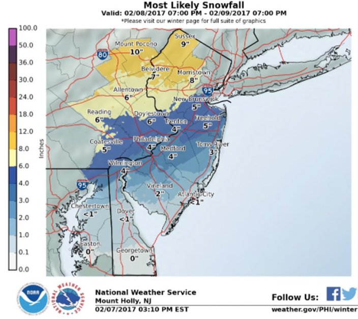 Source/National Weather Service
The precipitation still looks to commence as rain after midnight Thursday and eventually switch over to all snow, perhaps with a period of sleet in between. With the transition to snow along the I-95 corridor expected between 4 and 7 a.m., heavy snow and poor visibility will make for difficult driving conditions during the Thursday morning rush.
The snow should taper off in the Delaware Valley by midday Thursday. Winds out of the north-northwest will gusts from 20 to 30 mph in the afternoon.
Predictions of significant snow could seem silly on Wednesday afternoon, as the area basks in near-record, mid-60-degree temperatures. But the mercury will plummet by 30-plus degrees after sunset and remain near freezing through Thursday, forecasters said.
Here is the 7-day forecast from the weather service:
Tuesday night: Scattered showers, mainly before 5 a.m. Cloudy, with a low around 54. Southwest wind 11 to 15 mph. Chance of precipitation is 50 percent. New precipitation amounts of less than a tenth of an inch possible.
Wednesday: Mostly cloudy, with a high near 64. Southwest wind 7 to 11 mph becoming northwest in the afternoon.
Wednesday night: Rain, mainly after 1 a.m. Low around 32. Northwest wind 5 to 10 mph becoming northeast after midnight. Chance of precipitation is 90 percent. New precipitation amounts between a quarter and half of an inch possible.
Thursday: Rain and snow, becoming all snow after 8 a.m. High near 33. Northwest wind around 15 mph. Chance of precipitation is 90 percent. New snow accumulation of 1 to 3 inches possible.
Thursday night: A slight chance of snow before 1 a.m. Partly cloudy, with a low around 18. Chance of precipitation is 20 percent.
Friday: Mostly sunny, with a high near 35.
Friday night: Mostly cloudy, with a low around 29.
Saturday: Mostly cloudy, with a high near 46.
Saturday night: A chance of rain. Mostly cloudy, with a low around 39. Chance of precipitation is 40 percent.
Sunday: A chance of rain. Mostly cloudy, with a high near 53. Chance of precipitation is 40 percent.
Sunday night: A chance of rain. Mostly cloudy, with a low around 38. Chance of precipitation is 30 percent.
Monday: Mostly sunny, with a high near 49.
Tonight: Scattered showers, mainly between 3 a.m. and 5 a.m. Mostly cloudy, with a low around 50. Breezy, with a southwest wind 17 to 22 mph. Chance of precipitation is 30 percent. New precipitation amounts of less than a tenth of an inch possible.
Wednesday: A slight chance of showers before 1pm. Mostly cloudy, with a high near 59. Southwest wind 10 to 13 mph becoming northwest in the afternoon. Chance of precipitation is 20 percent.
Wednesday night: Rain, mainly after 1 a.m. Low around 37. Northeast wind 9 to 15 mph. Chance of precipitation is 90 percent. New precipitation amounts between a quarter and half of an inch possible.
Thursday: Rain before 10 a.m., then rain and snow between 10 a.m. and 11 a.m., then snow after 11 a.m. High near 38. Breezy, with a north wind 16 to 23 mph. Chance of precipitation is 90 percent. New snow accumulation of around an inch possible.
Thursday night: A slight chance of snow before 1 a.m. Partly cloudy, with a low around 23. Blustery. Chance of precipitation is 20 percent.
Friday: Sunny, with a high near 37.
Friday night: Mostly cloudy, with a low around 29.
Saturday: Mostly cloudy, with a high near 47.
Saturday night: Mostly cloudy, with a low around 39.
Sunday: A chance of rain. Mostly cloudy, with a high near 51. Chance of precipitation is 40 percent.
Sunday night: Mostly cloudy, with a low around 40.
Monday: Mostly sunny, with a high near 49. Breezy.