


February 15, 2016
 Staff Photo/PhillyVoice
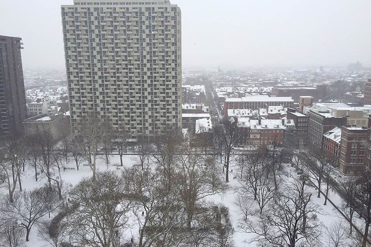
Snow blankets Washington Square in Old City on Monday afternoon. The snow will soon turn to sleet and then all-rain late tonight, forecasters said.
A winter storm moved into Philadelphia Monday afternoon and left a blanket of snow on roadways and sidewalks before letting up around 4 p.m. Soon after, though, sleet could be heard against the windows of Center City offices.
The wintry mix made for a slippery commute for many area motorists.
At 9 p.m., the mercury remained subfreezing – barely – at Philadelphia International Airport where freezing rain fell amid the fog and mist. The temperature there was 31 degrees.
Forecasters said the precipitation will eventually turn to rain as temperatures slowly rise through tonight and into Tuesday.
A Winter Weather Advisory posted by the National Weather Service is in effect for Philadelphia, the surrounding suburbs, south and north Jersey and northern Delaware. It expires at 11 p.m. Monday.
Very cold air has been slow to move out, but temperatures are already above freezing in coastal South Jersey and northern Delaware. Sleet is already mixing in and a changeover to rain should occur over the next few hours.
In South Jersey, central Delaware and Maryland, a mixture of snow, sleet and freezing rain was occurring with a transition to rain during the evening, the National Weather Service said.
Along the I-95 corridor, a changeover to all rain is expected by midnight, but as much as 0.10 inches of ice is possible before rain takes over.
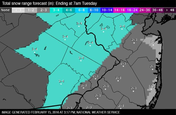
In the Berks County, the Lehigh Valley and most of northern New Jersey, a prolonged period of freezing rain will proceed the changeover to all rain late tonight. From 2 to 4 inches of snow is possible in addition to the ice.
Many roads, especially side roads and those that have not been pretreated, remained snow-covered and messy on Monday night with a light glaze of freezing rain or sleet falling on top of the snow. Motorists are advised to slow down and exercise caution.
.
The snow is creating difficulties on some area roadways:
Speeds on I-95, I-76, I-476, I-676, I-276, Route 422 and Route 309 were reduced to 45 mph.
In New Jersey, speeds were lowered to 45 mph on the Garden State Parkway and New Jersey Turnpike. Plowing operations are underway.
The snow affected Monday classes at some colleges and universities, as well. Montgomery County Community College canceled some classes and closed at 2 p.m. Villanova, Philadelphia University and Delaware University canceled late afternoon and evening classes and activities.
With temperatures expected to stay above freezing at dawn, Tuesday should be just rain, moderate to heavy at times, especially around noon. Rainfall totals will be in the half-inch to one-inch range in eastern Pennsylvania and northern New Jersey, and in the quarter-inch to three-quarter-inch range in southern and central New Jersey and Delaware.
Some small stream and poor drainage area flooding is possible.
Temperatures are expected to reach the 50s on Tuesday.
Here's the seven-day forecast from the weather service:
Monday Night: Rain, freezing rain, and sleet before 11pm, then freezing rain and sleet between 11pm and midnight, then rain after midnight. Temperature rising to around 41 by 5am. Light and variable wind becoming south 5 to 9 mph after midnight. Chance of precipitation is 100%. Total nighttime ice accumulation of less than a 0.1 of an inch possible. Total nighttime sleet accumulation of around an inch possible.
Tuesday: Rain. High near 54. Southeast wind 10 to 17 mph. Chance of precipitation is 90%. New precipitation amounts between three quarters and one inch possible.
Tuesday Night: A chance of rain before 8pm, then a chance of showers after 8pm. Mostly cloudy, with a low around 35. West wind 6 to 13 mph. Chance of precipitation is 40%. New precipitation amounts between a tenth and quarter of an inch possible.
Wednesday: A chance of showers, mainly before 1pm. Partly sunny, with a high near 46. Chance of precipitation is 40%. New precipitation amounts of less than a tenth of an inch possible.
Wednesday Night: Partly cloudy, with a low around 28.
Thursday: Sunny, with a high near 38.
Thursday Night: Mostly clear, with a low around 25.
Friday: Partly sunny, with a high near 43.
Friday Night: A chance of showers. Mostly cloudy, with a low around 35. Chance of precipitation is 30%.
Saturday: A chance of showers. Partly sunny, with a high near 53. Chance of precipitation is 30%.
Saturday Night: Partly cloudy, with a low around 34.
Sunday: Mostly sunny, with a high near 53.