
January 23, 2016
 Staff Photo/PhillyVoice
A snowman stands in Rittenhouse Square in Center City Philadelphia, putting a pretty face on a historic snowstorm expected to move out of the region later tonight.
It's almost out of here.
The monster winter storm that brought much of the East Coast to a standstill Saturday, with blizzard conditions, hurricane-force winds and major flooding at the Jersey Shore, is headed out to sea.
The National Weather Service said the snow is expected to taper off – from northwest to southeast – between 10 p.m. Saturday and 1 a.m. Sunday.
The snow stopped in Eastern Montgomery County about 8:15 p.m., but a few more inches of snow is likely in South Jersey before the nor'easter edges away from the coast.
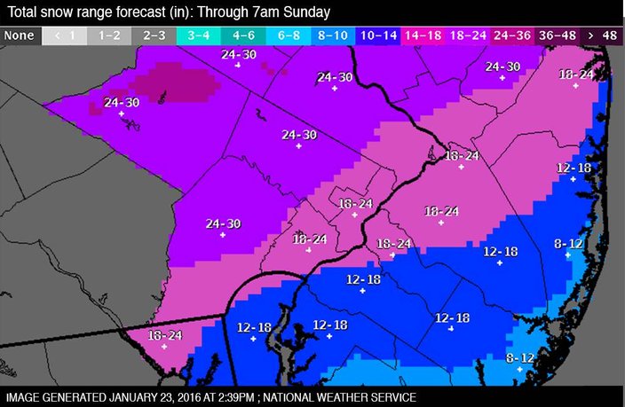
The still-deepening 17.1 inches of snow recorded at Philadelphia International Airport at 1 p.m. Saturday easily eclipsed the record for this date, set in 1935 with 11.9 inches of snow. There was a small chance that the blizzard would equal or better the city's average normal snowfall – 22.4 inches – for an entire season in just one storm, forecasters said. (See rolling snow counts for towns across the area.)
With 20.8 inches of snow in Philadelphia, the storm will claim at least sixth place on list of Top 10 prodigious snowfalls in the city. (Allentown, by contrast, set an all-time record of at least 30 inches.)
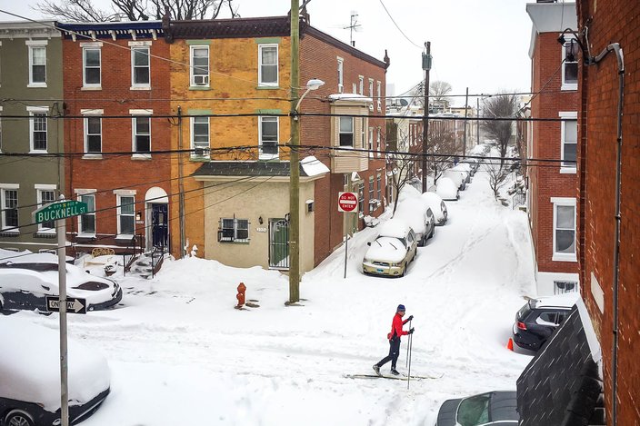
Fairmount resident, Brian Curtis cross-country skis along Parrish Street, Saturday, January 23, 2016.
Officials in Montgomery County announced Saturday evening that an elderly man in Lower Providence Township died in the blizzard while shoveling snow.
Towns along the Jersey Shore and coastal Delaware reported flooding that man feared could worsen late Saturday into Sunday morning as the tides rise again. Some residents along the coastline were under mandatory evacuations, and many more were asked to evacuate voluntarily.
A wind gust of 75 mph was recorded at Dewey Beach in Delaware, the strongest in the region. A 72-mph gust was recorded in Bayville, Ocean County.
The combination of heavy snowfall and strong winds has resulted in whiteout conditions all day Saturday, making travel extremely dangerous. Many roadways remain snow-covered and impassable at nightfall as road crews struggled to keep up with the wind-driven snow.
The Temple University women's gymnastics team was among travelers who got stuck when the Pennsylvania Turnpike turned into a snowy parking lot on Friday night.
The town of Collingswood in Camden County, like many in South Jersey was deserted Saturday, as most people stayed home to ride out the storm and shovel driveways.
Most transit succumbed to the storm, with all SEPTA service except for the subway and El closed down on Saturday, as was the Philadelphia International Airport. Amtrak ran for much of the day out of 30th Street Station, but eventually trips were being canceled. PATCO trains, however, ran throughout the storm.
SEPTA said late Saturday night that it is working to restore bus, trolley and Regional Rail service.
“There are number of challenges resulting from the storm, which has delivered snowfall totals that exceeded forecasted amounts,” SEPTA General Manager Jeffrey D. Knueppel said in a statement. The snow has pushed the expected 4 a.m. Sunday start time to 10 a.m. for many services, and even longer for certain routes and lines, he said.
By all accounts, it was a storm to remember. And not only for seeing Philadelphians throwing snowballs at TV news reporters.
After days of weather warnings, most of the 80 million people in the storm's path heeded requests to stay home and off the roads, which were largely deserted. Yet at least 18 deaths were blamed on the weather, resulting from car crashes, shoveling snow and hypothermia. And more snow was to come, with dangerous conditions expected to persist until early Sunday in New York and points north, forecasters warned.
"This is going to be one of those generational events, where your parents talk about how bad it was," Ryan Maue, a meteorologist for WeatherBell Analytics, said from Tallahassee, Florida, which also saw some flakes.
The system was mammoth, dropping snow from the Gulf Coast to New England. By afternoon, areas near Washington had surpassed 30 inches. The heaviest unofficial report was in a rural area of West Virginia, not far from Harper's Ferry, with 40 inches.
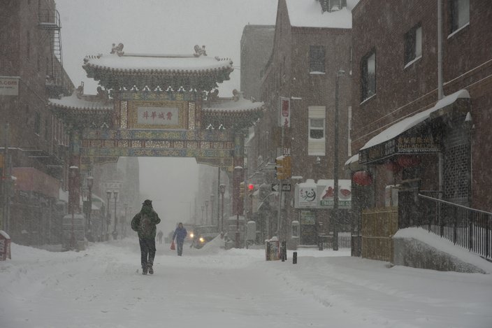
Snow covers the streets in Chinatown on Saturday morning.
As the storm picked up, forecasters increased their snow predictions for New York and points north and warned areas nearly as far north as Boston to expect heavy snow.
"This is kind of a Top 10 snowstorm," and likely a Top 5 for New York and Washington, said weather service winter storm expert Paul Kocin, who co-wrote a two-volume textbook on blizzards.
Drivers skidded off snowy, icy roads in accidents that killed several people as the storm raged Friday and Saturday. Those killed included a 4-year-old boy in North Carolina, a Kentucky transportation worker who was plowing highways, another Kentucky man whose car collided with a salt truck and a woman whose husband scaled a 300-foot-embankment to report that the couple's car had plunged down it and killed her.
An Ohio teenager sledding behind an all-terrain vehicle was hit by a truck and killed, and two people died of hypothermia in southwest Virginia. In North Carolina, a man whose car had veered off an icy-covered road was arrested on charges of killing a motorist who stopped to help.
.
Elsewhere, drivers were marooned for hours in snow-choked highways in Pennsylvania, Kentucky and West Virginia.
From Virginia to New York, sustained winds topped 30 mph and gusted to around 50 mph. The wind was so strong that scientists reported trouble measuring the snow because it sometimes seemed to blow sideways.
And if that weren't enough, the storm also had bursts of thunder and lightning. Forecasters saw lightning out the window of the Weather Prediction Center, where meteorologists were camped out.
The ice and snow canceled more than 4,400 flights on Saturday, bringing the weekend total to 6,300. Airlines hoped to be back in business by Sunday afternoon.
In its wake, the storm also knocked out electricity to thousands of homes and businesses.
• • •
Here's the mostly-dry forecast for the week from the weather service:
Tonight
Snow, mainly before 1 am. The snow could be heavy at times. Areas of blowing snow before 4 am. Low around 19. Blustery, with a north wind 20 to 25 mph decreasing to 14 to 19 mph after midnight. Winds could gust as high as 36 mph. Chance of precipitation is 100 percent. Total nighttime snow accumulation of 1 to 3 inches possible.
Sunday
Sunny, with a high near 33. Northwest wind 9 to 14 mph, with gusts as high as 24 mph.
Sunday Night
Partly cloudy, with a low around 19. West wind 3 to 6 mph.
Monday
Mostly sunny, with a high near 39. West wind 3 to 5 mph.
Monday Night
Mostly cloudy, with a low around 30. Light south wind.
Tuesday
A chance of showers, mainly after 1 pm. Mostly cloudy, with a high near 43. Chance of precipitation is 30 percent. New precipitation amounts of less than a tenth of an inch possible.
Tuesday Night
Mostly cloudy, with a low around 32.
Wednesday
Partly sunny, with a high near 39.
Wednesday Night
Partly cloudy, with a low around 23.
Thursday
Mostly sunny, with a high near 37.
Thursday Night
Mostly cloudy, with a low around 24.
Friday
Partly sunny, with a high near 39.
Friday Night
Mostly cloudy, with a low around 28.
The Associated Press contributed to this report.