January 05, 2017
 Thom Carroll/PhillyVoice
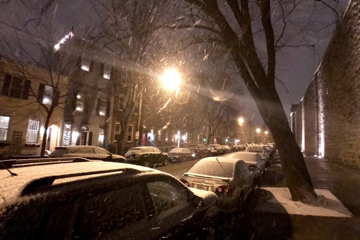
Snow falls in Fairmount Thursday evening along 22nd Street near Eastern State Penitentiary.
A winter weather advisory has been posted by the National Weather Service with snow expected to arrive a bit earlier than previously expected on Thursday night.
It will still have significant impact on the Friday morning commute, according to forecasters.
About 1 to 3 inches of accumulation are expected across the Philadelphia region, with the higher amounts east and south of the I-95 corridor toward the Jersey coast. Higher amounts are possible in some locations in central New Jersey.
Forecasters said a low pressure system will form off the Carolina coast late Thursday and head northeast.
The snow will start between 8 and 11 p.m. Thursday night, snow steadily overnight, and then end west-to-east between 3 and 6 a.m. The earlier-than-expected arrival of the storm could lessen impact a bit during the Friday morning rush hour, but forecasters are still warning that travel could be hazardous on Thursday night. Expect snow to cover roads, with untreated streets and sidewalks remaining slippery into the morning commute after the snow ends, the National Weather Service said.
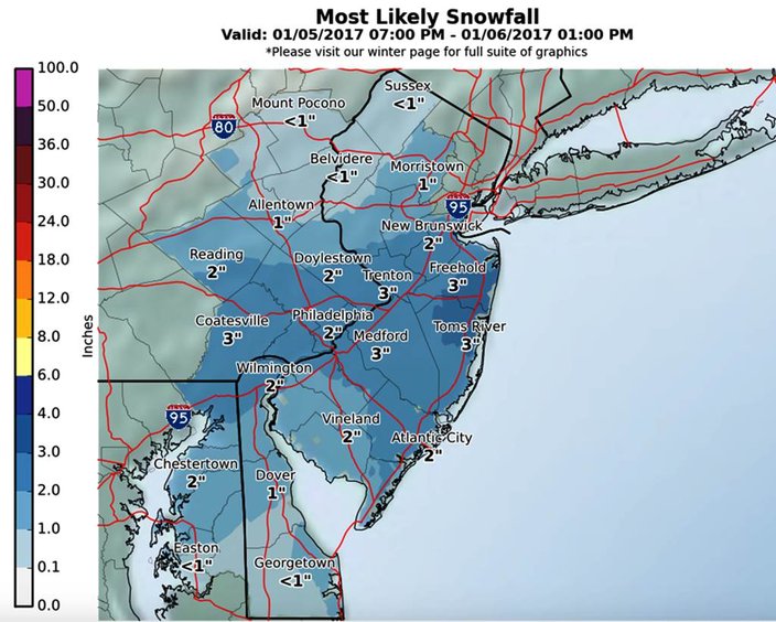 Source/National Weather Service
Temperatures will be steady in the high 20s and low 30s.
We'll barely have time to brush the snow off our windshields before another storm rolls by the region.
Forecasters have issued a winter storm watch for Atlantic and Cape May counties in New Jersey and Sussex County in Delaware for early Saturday morning through the day Saturday. Between 4 and 6 inches of snow are expected to accumulate in Cape May and Atlantic City, 1-2 inches in Mount Holly and less than inch on the Philadelphia side of the Delaware River.
There will be avery tight cutoff between those who see accumulating snow and no snow at all. People in the north and western suburbs of Philadelphia might even see a partly sunny day.
Temperatures will remain below freezing Saturday and down to 18 degrees at night. It gets colder on Sunday night – 14 degrees.
Code Blue alerts have been declared in a number of area counties, including Philadelphia, Montgomery and Camden counties.
In effect through 6 a.m. Tuesday, Philadelphia takes special measures to keep homeless people safe. If you see a person who appears to be homeless during a Code Blue, call (215) 232-1984.
• • •
Here are the 7-day forecasts for Philadelphia and the Jersey Shore from the NWS:
Thursday: Mostly cloudy, with a high near 36. West wind 8 to 10 mph.
Thursday night: Snow, mainly after 11 p.m. Low around 27. Southwest wind 3 to 5 mph. Chance of precipitation is 80 percent. New snow accumulation of 2 to 4 inches possible.
Friday: A chance of snow before 7 a.m. Mostly cloudy, with a high near 35. Northwest wind 6 to 9 mph. Chance of precipitation is 30 percent. New snow accumulation of less than a half inch possible.
Friday Night: Mostly cloudy, with a low around 20. West wind around 8 mph.
Saturday: A slight chance of snow after 8 a.m. Partly sunny, with a high near 30. North wind 7 to 9 mph. Chance of precipitation is 20 percent.
Saturday Night: A slight chance of snow before 8 p.m. Partly cloudy, with a low around 17. Chance of precipitation is 20 percent.
Sunday: Mostly sunny, with a high near 27. Blustery.
Sunday Night: Mostly clear, with a low around 14.
Monday: Sunny, with a high near 28.
Monday Night: Mostly cloudy, with a low around 21.
Tuesday: Partly sunny, with a high near 39.
Tuesday Night: Mostly cloudy, with a low around 32.
Wednesday: A chance of rain. Mostly cloudy, with a high near 50. Chance of precipitation is 40 percent.
Thursday: Mostly cloudy, with a high near 39. West wind 9 to 13 mph.
Thursday night: Snow, mainly between midnight and 5 a.m. Low around 29. Light and variable wind becoming north 5 to 8 mph after midnight. Chance of precipitation is 100 percent. New snow accumulation of 1 to 3 inches possible.
Friday: A chance of snow, mainly before 7 a.m. Mostly cloudy, with a high near 37. North wind around 14 mph. Chance of precipitation is 30 percent. New snow accumulation of less than a half inch possible.
Friday night: A slight chance of snow after 1 a.m. Mostly cloudy, with a low around 20. Northwest wind around 14 mph. Chance of precipitation is 20 percent.
Saturday: A chance of snow. Mostly cloudy, with a high near 31. North wind 13 to 16 mph. Chance of precipitation is 50 percent. New snow accumulation of less than a half inch possible.
Saturday night: Partly cloudy, with a low around 20.
Sunday: Mostly sunny, with a high near 29. Blustery.
Sunday night: Mostly clear, with a low around 17. Blustery.
Monday: Sunny, with a high near 30.
Monday night: Mostly cloudy, with a low around 25.
Tuesday: Partly sunny, with a high near 43.
Tuesday night: Mostly cloudy, with a low around 37.
Wednesday: A chance of rain. Mostly cloudy, with a high near 50. Breezy. Chance of precipitation is 30 percent.