March 14, 2018
 Source/NOAA National Environmental Satellite, Data, and Information Service (NESDIS)
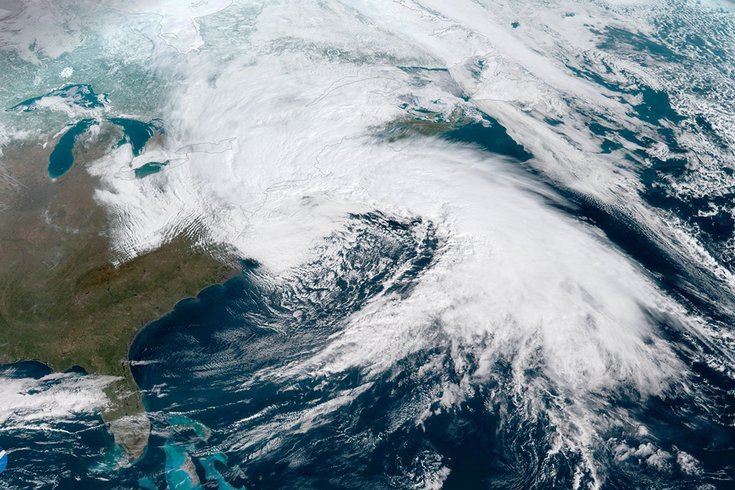
NOAA's GOES East satellite captured this dramatic image of the powerful nor'easter that brought gale-force winds, rain and snow to the Mid-Atlantic and Northeast on March 2, 2018.
Get ready for spring – it may be ushered in with yet another winter (?) storm.
The Spring Equinox is 12:15 p.m. Tuesday, the first day of the hotly-anticipated new season, the same day another nor'easter could form off the South Jersey-Delaware coast and bring inland snow, strong winds and who knows what else to the region.
If – and we're screaming IF – it happens it would be the fourth nor'easter in these parts in less than 3 weeks.
Forecasters are seeing early weather models begin to suggest that a large storm likely to track over the Central states early next week will head this way. That storm or a secondary storm may strengthen off the Mid-Atlantic coast by the middle of next week.
The National Weather Service says right upfront that impacts from this storm in the crystal ball are uncertain right now. It does say, however, there is potent potential for such a storm from Tuesday to early Wednesday.
Forecasters said the storm from the Central Plains could interact with energy moving southward from southern Canada. If low pressure stays to the south – with cold air staying in place – the storm could moves off the Mid-Atlantic coast on Tuesday night.
But if the storm tracks into our area to the north, that could potentially trigger the development of a secondary storm that could draw in warmer area for a period before it moves to the north.
The track of the storm across the country then is key to what type of precipitation – and how much –we might see during this event.
For now, the weather service's Mount Holly office is favoring the NOAA Weather Prediction Center's forecast of the second scenario – development of a secondary storm.
The threat of more winter storms during the early weeks of spring is quite possible, writes meteorologist Alex Sosnowski of Accu-Weather:
Right around when March began, a change in the weather pattern occurred that caused the jet stream to buckle around the Northern Hemisphere. This buckling allowed cold air to consistently get jammed across eastern Canada and the northeastern U.S. The same pattern allowed storms to strengthen upon approaching the Northeast.
While this blocking pattern will change and weaken somewhat, the cold air will still put up a fight for the second half of March in the Northeast.
Hap-py day...
Here's the 7-day forecast for Philadelphia from the weather service:
Wednesday: Scattered showers. Cloudy, with a high near 42. West wind around 18 mph, with gusts as high as 33 mph. Chance of precipitation is 30 percent. New precipitation amounts of less than a tenth of an inch possible.
Wednesday night: Scattered snow showers before 7 p.m., then a slight chance of rain showers till 8 p.m. Mostly cloudy, with a low around 30. West wind 13 to 17 mph, with gusts as high as 37 mph. Chance of precipitation is 30 percent. Little or no snow accumulation expected.
Thursday: A chance of showers after 2 p.m. Partly sunny, with a high near 46. West wind 8 to 13 mph. Chance of precipitation is 30 percent. New precipitation amounts of less than a tenth of an inch possible.
Thursday night: A chance of showers before 8 p.m. Partly cloudy, with a low around 30. West wind 10 to 14 mph. Chance of precipitation is 30 percent. New precipitation amounts of less than a tenth of an inch possible.
Friday: Mostly sunny, with a high near 40. West wind 15 to 17 mph.
Friday night: Mostly clear, with a low around 26.
Saturday: Sunny, with a high near 45.
Saturday night: Partly cloudy, with a low around 29.
Sunday: Sunny, with a high near 51.
Sunday night: Mostly clear, with a low around 33.
Monday: Sunny, with a high near 48.
Monday night: Mostly cloudy, with a low around 30.
Tuesday: A chance of rain and snow. Cloudy, with a high near 40. Chance of precipitation is 40 percent.
Tuesday night: A chance of rain and snow. Mostly cloudy, with a low around 31. Chance of precipitation is 40 percent.
Wednesday: Partly sunny, with a high near 44.