
August 31, 2016
 Source/NOAA
Hurricane Gaston is kicking up coastal waves Wednesday. Tropical Storm Hermine will follow. The two storms will make for the possibility of rough surf through Monday off the Jersey and Delaware coasts.
A distant hurricane now in the central Atlantic, followed by a tropical depression making its way north from Florida, will make for big waves and rip currents heading into – and during – the Labor Day weekend, according to the National Weather Service.
Surf action that began due to Hurricane Gaston, now east of Bermuda, will continue through Wednesday evening, then abate Thursday into Friday. But it is likely to pick back up for the holiday weekend.
Bobby Martrich, a meteorologist with the Eastern PA Weather Authority, tweeted Wednesday morning that some "sick waves" might be expected.
Related story: 2016 South Jersey Shore beach guide
Michael Silva, a meteorologist with the NWS office in Mount Holly, says there is "no good handle" yet on Tropical Storm Hermine's track, its wave heights or its rain bands.
"The forecast is uncertain," he said Wednesday afternoon, adding different forecast models are in conflict for now.
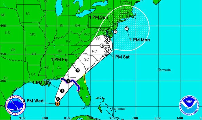
The anticipated track of Tropical Storm Hermine as forecast by the National Weather Service. Meteorologists, however, note that weather models are conflicting and a more definitive track is unknown at this time.
The weather service has warned this week of dangerous rip currents with rough surf conditions Jersey Shore and Delaware beaches, and says their severity would worsen over the weekend.
Hermine became a named storm at 1 p.m. Wednesday with sustained winds of at least 40 miles per hour.
Silva said the storm, which is in the center of the Gulf of Mexico, will hit Florida and travel across the panhandle into the Atlantic Ocean, somewhere off the coast of northern Florida or southern Georgia.
It will head along the coast, tracking toward North Carolina beaches, but after the Carolinas its course is uncertain, said Silva.
"We really don't know what it is going to do Saturday, Sunday and maybe into Monday," said the meteorologist.
"It is really hard to tell if the rain bands will touch New Jersey. And we don't know how rough it will be, but it could be dangerous," and lead to restrictions on beaches, he added.
"It is entirely too soon to predict the size of the surf," said Silva.
But the Weather Service has cautioned that breakers of six feet are possible. Unexpected "sleeper waves" that are more forceful than other waves in their set are also possible, according to a warning statement.
On the temperature side, heat and humidity will break heading into the weekend, with coastal temps in the upper 70s to low 80s.
But humidity could zoom back up if the storm come close to the shore, added Silva.
Here is the holiday weekend forecast for Philadelphia, the Jersey Shore and the Poconos:
PHILADELPHIA
Tonight: Showers and thunderstorms likely, then showers and possibly a thunderstorm after 2am. Some of the storms could produce heavy rain. Patchy fog after 2am. Low around 72. South wind 5 to 7 mph becoming calm in the evening. Chance of precipitation is 80%. New rainfall amounts between a tenth and quarter of an inch, except higher amounts possible in thunderstorms.
Thursday: Showers likely, mainly before 7am. Patchy fog before 8am. Otherwise, cloudy, with a high near 83. Calm wind becoming north 5 to 7 mph in the morning. Chance of precipitation is 60%. New precipitation amounts between a tenth and quarter of an inch possible.
Thursday Night: Partly cloudy, with a low around 65. North wind 8 to 10 mph.
Friday: Sunny, with a high near 82. North wind 8 to 10 mph.
Friday Night: Partly cloudy, with a low around 65. Northeast wind around 6 mph.
Saturday: A chance of rain after noon. Partly sunny, with a high near 77. Chance of precipitation is 30%.
Saturday Night: A chance of rain. Mostly cloudy, with a low around 63. Chance of precipitation is 40%.
Sunday: A chance of rain. Partly sunny, with a high near 75. Chance of precipitation is 40%.
Sunday Night: Mostly cloudy, with a low around 65.
Labor Day: Partly sunny, with a high near 82.
Monday Night: Partly cloudy, with a low around 65.
Tuesday: Sunny, with a high near 88.
JERSEY SHORE
Tonight: A chance of showers and thunderstorms, then showers likely and possibly a thunderstorm after 2am. Some of the storms could produce heavy rain. Patchy fog after 2am. Otherwise, increasing clouds, with a low around 72. Southwest wind 5 to 8 mph. Chance of precipitation is 70%. New rainfall amounts between a tenth and quarter of an inch, except higher amounts possible in thunderstorms.
Thursday: Showers likely, mainly before 9am. Patchy fog before 8am. Otherwise, cloudy, with a high near 81. West wind 5 to 7 mph becoming north in the afternoon. Chance of precipitation is 60%. New precipitation amounts between a tenth and quarter of an inch possible.
Thursday Night: Partly cloudy, with a low around 64. North wind 5 to 7 mph.
Friday: Sunny, with a high near 80. North wind 10 to 14 mph.
Friday Night: Partly cloudy, with a low around 63. East wind 5 to 9 mph.
Saturday: A chance of rain after noon. Partly sunny, with a high near 75. Breezy. Chance of precipitation is 30%.
Saturday Night: A chance of rain. Mostly cloudy, with a low around 66. Breezy. Chance of precipitation is 40%.
Sunday: A chance of rain. Partly sunny, with a high near 75. Chance of precipitation is 40%.
Sunday Night: A chance of rain. Mostly cloudy, with a low around 67. Chance of precipitation is 40%.
Labor Day: Partly sunny, with a high near 79.
Monday Night: Partly cloudy, with a low around 69.
POCONOS
This Afternoon: A chance of showers and thunderstorms. Some of the storms could produce heavy rain. Mostly cloudy, with a high near 79. West wind around 6 mph. Chance of precipitation is 50%. New rainfall amounts of less than a tenth of an inch, except higher amounts possible in thunderstorms.
Tonight: A chance of showers and thunderstorms before 9pm, then showers likely and possibly a thunderstorm between 9pm and 1am, then a chance of showers and thunderstorms after 1am. Some of the storms could produce heavy rain. Patchy fog after 2am. Otherwise, cloudy, with a low around 63. Light and variable wind. Chance of precipitation is 70%. New rainfall amounts between a quarter and half of an inch possible.
Thursday: A chance of showers, mainly before 10am. Patchy fog before 8am. Otherwise, cloudy, then gradually becoming mostly sunny, with a high near 75. Light northwest wind becoming north 5 to 10 mph in the morning. Chance of precipitation is 30%. New precipitation amounts of less than a tenth of an inch possible.
Thursday Night: Mostly clear, with a low around 53. North wind around 9 mph.
Friday: Sunny, with a high near 73. North wind around 9 mph.
Friday Night: Partly cloudy, with a low around 53.
Saturday: A chance of rain after noon. Partly sunny, with a high near 72. Chance of precipitation is 30%.
Saturday Night: A chance of rain. Mostly cloudy, with a low around 54. Chance of precipitation is 40%.
Sunday: A chance of rain. Partly sunny, with a high near 71. Chance of precipitation is 40%.
Sunday Night: Mostly cloudy, with a low around 57.
Labor Day: Partly sunny, with a high near 75.
Monday Night: Partly cloudy, with a low around 57.
Tuesday: Sunny, with a high near 81.