


April 20, 2015
 National Weather Service/Storm Prediction Center
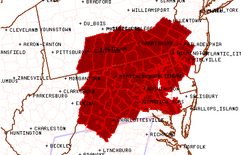
The NWS Map of the tornado watch area in effect Monday afternoon until 10 p.m.
The National Weather Service issued a tornado watch for most of the Delaware Valley on Monday, but one never came through the region. The watch went in to effect at 3 p.m. on Monday and remained in effect until it expired at 12 a.m. Tuesday morning.
The watch, which was originally set in place until 10 p.m., was extended to midnight in Philadelphia County along with several surrounding counties in Southeastern Pennsylvania, Northern Delaware and Southwest New Jersey. For the full list of cities and counties, click here.
The original watch area extended south in to areas in Northern Virginia and west to Harrisburg to include a large section of Southern Pennsylvania. The original NWS map of the area for the tornado watch issued until 10 p.m. can be seen here:
The watch that was extended until midnight included a smaller region, mainly the Delaware Valley, which can be seen in 6 ABC's Cecily Tynan's map that she tweeted out earlier tonight:
The tornado watch has been extended until midnight as clusters of storms from central Pa. and down by D.C. close in. pic.twitter.com/5d9J1pltbn
— Cecily Tynan (@CecilyTynan) April 21, 2015
According to the NWS, the chances of two or more tornadoes was moderate at 40 percent, while the chances of a strong tornado, or one at an intensity level between F2 to F5, was low at 20 percent.
NBC Philadelphia reports that heavy lightning, rain and winds have moved in and are expected to continue overnight. A possibility of hail could accompany the storm, but it should clear up before the morning commute.