


December 30, 2017
 Andrew Parent/PhillyVoice
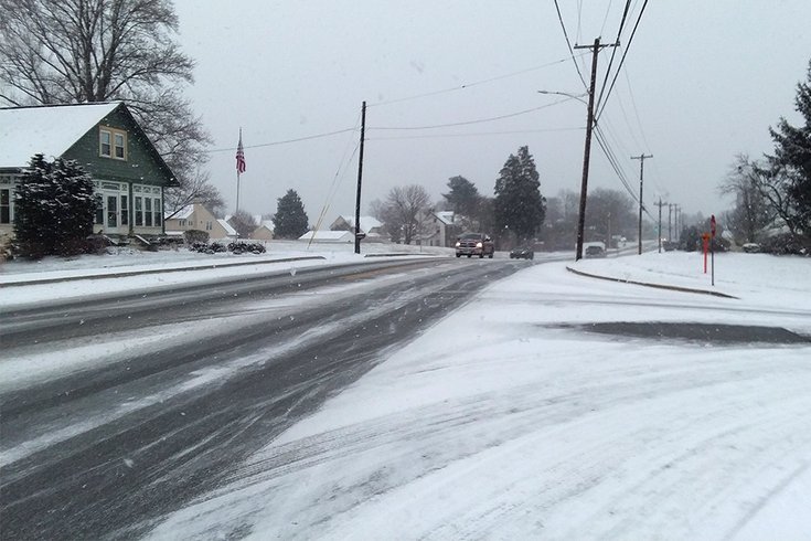
Traffic moves along a mostly clear Naaman’s Creek Road in Garnet Valley, Delaware County on Saturday morning. Many side streets throughout the region remain snow-covered, however.
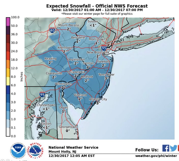
The snowfall looks to get a bit deeper on Saturday than originally expected.
In fact, the National Weather Service has declared a winter weather advisory from 6 a.m. to 6 p.m.
Forecasters now say up to 3 inches of snow are possible from Chester County and eastward through Philadelphia and to the Jersey Shore. The advisory covers a wide swath of the region – from Kennett Square to Cape May to Long Beach Island and westward to Lansdale.
Bucks County and points north could see from 1-2 inches of snow.
The snow was falling steadily mid-morning in Garnet Valley, Delaware County, and Maple Glen, Montgomery County, with about an inch of snow on the ground by 10:30 a.m.
The snow is courtesy of an Alberta clipper moving into the Mid-Atlantic from Canada that will throw a bit of moisture into our extended Arctic blast – a record low temperature of 9 degrees was tied Thursday in Atlantic City.
The snow was expected to fall through mid-day. Light winds during most of the day should begin to pick up by late afternoon as a cold front moves through.
The very cold temperatures and dry snow will create slick driving conditions and reduced visibilities on area roads, forecasters warned. It's also possible that melt-off and slush from the morning snow could refreeze at night as temperatures fall further into the teens.
In Camden County, preparations for plowing and salting already have begun.
Ironically, the snow will come on what looks to be the warmest day at least through midweek – only 10 to 12 degrees below normal.
The warmup is temporary though, with temperatures plummeting to 20 degrees below normal before the Eagles' 1 p.m. kickoff at the Linc on Sunday and expected to last into Monday. Sub-zero winds chills will be seen across the region on both days with less than -15 across the southern Poconos.
The City of Philadelphia and other surrounding counties have Code Blue declarations in effect due to the extreme cold. City authorities ask that you call (215) 232-1984 for homeless outreach if you see people out on the street. And check on your elderly neighbors to make sure they have working heat and help them out so they don't have to go outside.
The good news? Snow of any significance is not expected early next week. Though some weather models indicated Thursday another low pressure system with a possibility of more snow next Wednesday, subsequent models now show it moving further off the coast. But uncertainty remains as to what the area sees out of that storm.
.
Here's the 7-day forecast from the weather service:
Saturday: Snow. High near 27. Calm wind becoming west 5 to 9 mph in the afternoon. Chance of precipitation is 90 percent. New snow accumulation of 1 to 3 inches possible.
Saturday night: A chance of snow before 8 p.m. Partly cloudy, with a low around 18. Northwest wind 9 to 13 mph. Chance of precipitation is 30 percent. New snow accumulation of less than a half inch possible.
Sunday: Mostly sunny, with a high near 21. Northwest wind around 13 mph.
Sunday night: Partly cloudy, with a low around 10.
New Year's Day: Mostly sunny, with a high near 19.
Monday night: Mostly clear, with a low around 11.
Tuesday: Sunny, with a high near 23.
Tuesday night: Mostly clear, with a low around 13.
Wednesday: A chance of snow. Partly sunny, with a high near 29. Chance of precipitation is 30 percent.
Wednesday night: A chance of snow. Mostly cloudy, with a low around 20. Chance of precipitation is 30 percent.
Thursday: Partly sunny, with a high near 27.