


January 15, 2024
 @NWS_MountHolly/X (Formerly Twitter)
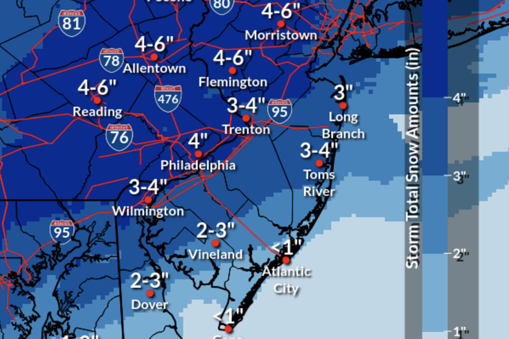
Forecasts from the National Weather Service predict 2-4 inches of snow falling on the Philadelphia and the rest of the region between Monday night and Tuesday.
After 716 days, Philly’s record-long snow drought is likely to end. The Philadelphia region could get as much as 4 inches of snow between Monday evening and Tuesday morning, according to the latest forecasts from the National Weather Service.
Following a Code Blue emergency issued Sunday as temperatures dipped into freezing numbers, the upcoming storm system is the first of two that could bring winter weather to the Delaware Valley this week. Another storm that is currently forecast to reach the Philadelphia area on Friday is likely to result in more snow, according to the NWS.
The last time Philly got an inch or more of snow was Jan. 29, 2022, according to the NWS. That storm dumped a total of 7 1/2 inches in Philadelphia and 16 inches in Atlantic City. While the city and nearby areas have seen periodic dustings and wet mixtures of wintry precipitation since then, there hasn’t been a meaningful accumulation in the Philadelphia region in nearly two years.
Late last year, the Philadelphia set a new record for the longest stretch without snow, surpassing the streak that ended in 1973.
Experts expect snowy winter in the Philadelphia region this year, predicting about 25 inches of snowfall, according to predictive models from PA Weather Action. The same model predicts as much as 83 inches of snow in Susquehanna County, in the northeastern corner of the state, and 120 inches in parts of Southwestern Pennsylvania.
Here is the latest daily forecast for Philadelphia from the NWS:
MONDAY: Low around 28 degrees. Chance of precipitation is 80%. New snow accumulation of 2-4 inches.
TUESDAY Snow likely before 1 p.m. Cloudy, with a high near 34 degrees. Chance of precipitation is 70%. New snow accumulation of 1-2 inches possible. Low around 19 overnight.
WEDNEDAY: Sunny, with a high near 26 degrees. Overnight low around 21.
THURDAY: Cloudy, high temperature near 32. A 40% chance of snow after 1 a.m. Low around 25 degrees.
FRIDAY: Snow likely before 1 p.m. Cloudy, high near 31. Chance of precipitation is 60%. Overnight, 30% chance of snow before 1 a.m. Low temperature around 18 degrees.
SATURDAY: Mostly sunny, with a high near 25 and a low of 14. Blustery winds.