


February 20, 2026
 @NWS_MountHolly/X
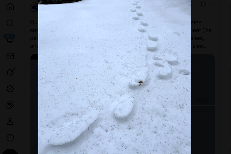
Inverse footprints in the snow are caused when sleet fills up tracks that were made during a storm. Freezing temperatures preserve the pockets of ice, which melt slower than the surrounding snow. Above, a trail of inverse tracks in Trenton.
For weeks, the wintry aftermath of snowstorms in late January left much of the Northeast blanketed with snow and ice as temperatures steadily held below freezing.
The snowpack is only now melting significantly, and in some places, it's leaving behind the remnants of footsteps from the initial mix of snow and sleet that fell last month.
MORE: Isaiah Zagar, who covered South Philly in murals, dies at 86
The National Weather Service in Mount Holly posted photos Thursday that show odd-looking examples of inverse tracks in the snow in Trenton. The phenomenon is caused by the sequence of sleet falling after snow. The footprints where people walked during the initial snowfall got filled with pockets of ice from the sleet, and now the surrounding snow is melting faster than the icy impressions of footsteps.
Our Trenton snow observer photographed these yesterday... inverse snow tracks! The snow was walked in when it was changing to sleet (ice pellets) back on January 25th, then the footprints filled up with sleet, and now the softer snow around them is melting faster than the sleet. pic.twitter.com/rLJvruzZrb
— NWS Mount Holly (@NWS_MountHolly) February 19, 2026
"When the sleet fell, a lot of it ended up bouncing into the footprints and knocking some snow in," NWS meteorologist Ray Martin said. "You get a lot of excess accumulation of the sleet in the footprints. Obviously, it was very cold and everything was stable for a while, but now that it's melting, you have the extra sleet in those footprints. That's a much larger mass of ice. There's a lot more water in that pool of compacted sleet than there is in the regular snowpack."
Several people who saw NWS's Facebook post replied with photos of inverse footprints they spotted in their own communities. As remnants of winter storms go, they're a lot more palatable than the piles of weeks-old dog poop that people are finding in their neighborhoods in the wake of the melted snow.
Large parts of the Northeast and Mid-Atlantic regions are in the midst of the coldest winter in recent memory.
Based on temperatures recorded at the Philly airport from the start of December through Feb. 19, this has been the coldest winter in the city since 2011. The nine-day streak of below-freezing temperatures from late January into February was the longest recorded since 2004. (The record still stands at 15 consecutive days in 1979 and 1961.)
Rivers, lakes and other bodies of water remained frozen for weeks during the cold snap — and many cities in the Northeast are still icy. Lake Erie, the shallowest of the Great Lakes, was 96% frozen on Feb. 5. Drone footage from the lake showed an 80-mile-long fracture that formed Feb. 8, extending from Port Burwell, Ontario, to just outside Cleveland.
🧊CRACKING UP: Drone video captured an 80-mile-long crack that developed on frozen Lake Erie earlier this week, which was visible from space. pic.twitter.com/udZoE5i8so
— FOX Weather (@foxweather) February 10, 2026
The meteorological winter is measured from Dec. 1 through the end of February, so the rest of the month will determine how this winter stacks up historically, Martin said.
The Philadelphia region could be in line for more snow. The current forecast calls for a wintery mix starting Sunday afternoon and continuing into Monday morning. The high Sunday is expected to hit 39 degrees with a low of 31. Monday's high is 39 degrees with a low of 26.