


April 06, 2026
 Provided Image/New Jersey Department of Environment Protection
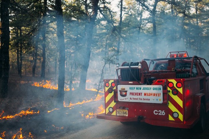
Although it rained Sunday and a cold front is blowing in from Canada, part of New Jersey and Pennsylvania are at an elevated risk of fire spread. Above, firefighters battle a blaze in March 2025.
Portions of South Jersey and Pennsylvania are experiencing an elevated risk of wildfires this week despite recent rain and an upcoming cold front.
The National Weather Service's Mount Holly station said weather conditions that are more conducive to fire spreading is in place on Monday and Tuesday. While it's not enough to issue a red flag warning, which calls for limiting controlled burns, a dry air mass means the area will be "very close to exceeding" that criteria Tuesday.
On Tuesday evening, a cold front will move into the area, causing temperatures to drop into the 20s and 30s, according to the NWS forecast.
Ray Martin, a meteorologist at NWS, said this fire potential is typical for this time of year. Dry air masses often move in from Canada in April with low dew points so that there's less moisture in the air. Dry leaves and branches pile up to provide ample fuel for flames.
"This time of year, (debris) can dry up very quickly, since the sun is still breaching the forest floor, there's no leaves on most of the trees yet," Martin said. "So that, combined with the low humidity and gusty winds means that any fires that are accidentally started could spread rapidly."
Sunday's rains mean most of the leaves on the ground are still wet, which is why Monday's risk is lower. But they can dry out in just one to two days, so last week's rains do little to keep things moist. Most of Southeastern Pennsylvania and South Jersey is experiencing either abnormally dry or moderate drought conditions, as well, according to the National Integrated Drought Information System, further increasing wildfire risks.
The dry air is also worsened by the lack of evapotranspiration, which is when plants release water back into the air while they're growing. This time of year, there aren't very many plants contributing to that process just yet.
Those factors are what makes early spring more risky for wildfires than hot dry spells in the summer.
Though fire conditions will worsen between Monday and Tuesday, Martin expects things to mellow out for the rest of the week. However, he said it's likely that there will be red flag warnings and possible fire spread throughout April, as it's peak wildfire season for this area. Thus, he said residents should take caution with campfires and backyard blazes.
"You really want to be careful with anything fire-related because it can spread pretty quickly," Martin said. "It only takes a few minutes to have a surprise fire on your hands."