


June 28, 2018
It hasn't exactly been a long hot summer so far, but that looks to change soon.
In fact, an extended heat wave is set to begin Friday.
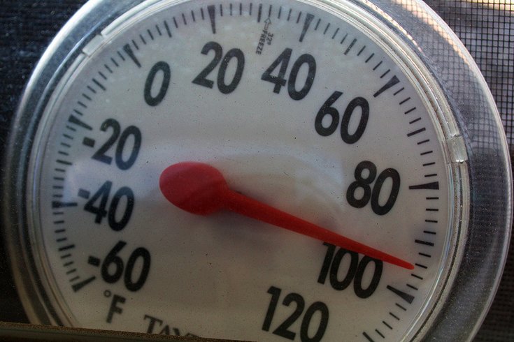
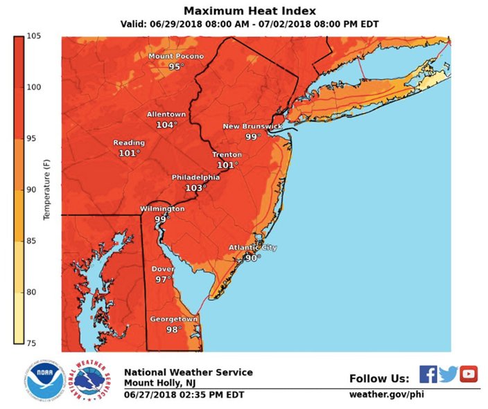
The heat and humidity get even worse on Sunday and Monday, with a potential triple-digit heat index.
Showers and thunderstorms look to move into the area on Monday and perhaps remain into the Fourth of July on Wednesday, with more seasonal temperatures expected on the holiday.
But forecasters say the heat looks to return by the end of next week and last through next weekend.
Here's what to expect in the days ahead, according to the weather service:
On Thursday night, dry air moving into the region from the northwest should mean clearing skies and low temperatures in the 60s. In the city, and points south, some places may not fall out of the 70s.
On sunny Friday, the heat and humidity begin to ramp up, with high temperatures in the low 90s and a low in the low 70s at night.
Temperatures rise to near 97 degrees on Saturday and a heat index approaching 100 degrees under sunny skies with just calm winds. The low will be in the mid-70s. A heat advisory in the I-95 urban corridor is possible.
It gets hotter on Sunday. The mercury climbs another couple of degrees and a heat index of 105 looks possible under more sunny skies. The low will be in the mid-70s. A heat warning is possible.
(The record highs for those dates in Philadelphia are 100 degrees on June 30 (1964), 102 on July 1 (1901) and 103 on July 2 (1901).)
Temperatures dip slightly Tuesday but mostly sunny skies continue. High temperatures of 95 expected with a low near 74.
On Wednesday, the Fourth of July, the high temperature falls to near 92, with a 30 percent chance of showers and thunderstorms.
The mercury is expected to climb again later next week and continue through the weekend, forecasters said.
Here is the 7-day forecast from the weather service for Philadelphia, the Jersey Shore and the Poconos:
Thursday night: Mostly cloudy, then gradually becoming clear, with a low around 71. Northwest wind around 6 mph.
Friday: Sunny, with a high near 92. Northwest wind 5 to 9 mph.
Friday night: Mostly clear, with a low around 72. West wind around 6 mph becoming calm in the evening.
Saturday: Sunny, with a high near 95. Calm wind becoming west around 6 mph in the afternoon.
Saturday night: Mostly clear, with a low around 75.
Sunday: Sunny and hot, with a high near 97.
Sunday night: Mostly clear, with a low around 76.
Monday: Sunny and hot, with a high near 97.
Monday night: Partly cloudy, with a low around 76.
Tuesday: Mostly sunny, with a high near 95.
Tuesday night: Partly cloudy, with a low around 74.
Independence Day: A chance of showers and thunderstorms. Mostly sunny, with a high near 92. Chance of precipitation is 30 percent.
Wednesday night: A chance of showers and thunderstorms. Mostly cloudy, with a low around 73. Chance of precipitation is 30 percent.
Thursday: A chance of showers and thunderstorms. Mostly sunny, with a high near 91.
Thursday night: Scattered showers and thunderstorms, mainly before 7 p.m. Mostly clear, with a low around 70. Southwest wind 5 to 7 mph. Chance of precipitation is 30 percent. New precipitation amounts of less than a tenth of an inch, except higher amounts possible in thunderstorms.
Friday: Sunny, with a high near 84. Northwest wind 6 to 9 mph becoming southwest in the afternoon.
Friday night: Mostly clear, with a low around 71. Southwest wind 3 to 8 mph.
Saturday: Sunny, with a high near 87. Calm wind becoming southwest 5 to 8 mph in the afternoon.
Saturday night: Mostly clear, with a low around 72.
Sunday: Sunny, with a high near 86.
Sunday night: Mostly clear, with a low around 74.
Monday: Sunny, with a high near 84.
Monday night: Mostly clear, with a low around 74.
Tuesday: Mostly sunny, with a high near 83.
Tuesday night: Partly cloudy, with a low around 73.
Independence Day: Mostly sunny, with a high near 82.
Wednesday night: Partly cloudy, with a low around 73.
Thursday: Mostly sunny, with a high near 80.
Thursday night: Partly cloudy, with a low around 63. Northwest wind around 7 mph.
Friday: Sunny, with a high near 84. Northwest wind 6 to 10 mph.
Friday night: Mostly clear, with a low around 63. Northwest wind around 5 mph becoming calm in the evening.
Saturday: Sunny, with a high near 88. Calm wind becoming west 5 to 8 mph in the morning.
Saturday night: Mostly clear, with a low around 68.
Sunday: Sunny, with a high near 91.
Sunday night: Mostly clear, with a low around 70.
Monday: A chance of showers and thunderstorms after 2 p.m. Sunny, with a high near 90. Chance of precipitation is 30 percent.
Monday night: A chance of showers and thunderstorms. Partly cloudy, with a low around 70. Chance of precipitation is 30 percent.
Tuesday: A chance of showers and thunderstorms. Mostly sunny, with a high near 87. Chance of precipitation is 30 percent.
Tuesday night: A chance of showers and thunderstorms. Mostly cloudy, with a low around 69. Chance of precipitation is 30 percent.
Independence Day: A chance of showers and thunderstorms. Partly sunny, with a high near 85. Chance of precipitation is 30 percent.
Wednesday night: A chance of showers and thunderstorms. Partly cloudy, with a low around 68. Chance of precipitation is 30 percent.
Thursday: A chance of showers and thunderstorms. Partly sunny, with a high near 85.