


August 02, 2020
 Courtesy of/National Weather Service
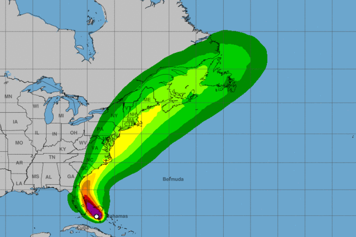
Strong winds, heavy rain, and flooding are expected across the Philly region starting on Monday night and continuing through Tuesday night, according to the National Weather Service.
Tropical Storm Isaias is forecasted to arrive in the Philadelphia region on Monday night and is expected to bring heavy rain, flooding, and strong winds through Tuesday night, according to the National Weather Service.
Significant rainfall across the entire region is expected to start Monday night and continue through Tuesday night, potentially leading to flash flooding and poor drainage flooding for inland locations such as along the I-95 corridor.
Stream and river flooding is also possible, especially in Southeastern Pennsylvania and parts of New Jersey.
Strong winds are expected to arrive during the day on Tuesday, with wind speeds potentially reaching 73 MPH. The strong winds could lead to tree and power line damage.
The highest risk of wind damage is expected along the Jersey Shore, leading to an increased risk of rip currents and swells starting this weekend and continuing through at least Wednesday.
Tropical storms conditions are possible, especially for coastal locations along the Jersey Shore. Heavy rain could lead to coastal flooding and storm surge, especially around high tide on Tuesday.
There is still some uncertainty over the future track, intensity, and timing of the storm, the National Weather Service said. Any change in the path of the storm will impact how far inland tropical storm force winds extend.
Here is a complete forecast from the National Weather Service for the next three days.
Sunday: A slight chance of showers and thunderstorms after 1pm. Some of the storms could produce gusty winds. Partly sunny, with a high near 92. Heat index values as high as 100. Southwest wind 5 to 10 mph, with gusts as high as 20 mph. Chance of precipitation is 20%.
Sunday night: A chance of showers and thunderstorms, mainly before 2am. Some of the storms could produce gusty winds. Mostly cloudy, with a low around 76. Southwest wind 5 to 10 mph. Chance of precipitation is 30%. New rainfall amounts of less than a tenth of an inch, except higher amounts possible in thunderstorms.
Monday: A slight chance of showers before 2pm, then showers likely and possibly a thunderstorm between 2pm and 5pm, then showers and thunderstorms likely after 5pm. Partly sunny, with a high near 89. West wind around 5 mph. Chance of precipitation is 60%. New rainfall amounts between a tenth and quarter of an inch, except higher amounts possible in thunderstorms.
Monday night: Showers and thunderstorms likely, then showers and possibly a thunderstorm after 8pm. Some of the storms could produce heavy rain. Low around 73. South wind around 5 mph. Chance of precipitation is 80%. New rainfall amounts between a half and three quarters of an inch possible.
Tuesday: Showers and possibly a thunderstorm. Some of the storms could produce heavy rain. High near 79. South wind 5 to 10 mph. Chance of precipitation is 90%. New rainfall amounts between 1 and 2 inches possible.
Tuesday night: Showers likely and possibly a thunderstorm before 2am, then a chance of showers and thunderstorms after 2am. Mostly cloudy, with a low around 71. Breezy. Chance of precipitation is 60%. New rainfall amounts between 1 and 2 inches possible.
Follow Pat & PhillyVoice on Twitter: @Pat_Ralph | @thePhillyVoice
Like us on Facebook: PhillyVoice
Add Pat's RSS feed to your feed reader
Have a news tip? Let us know.