
December 24, 2021
 Contributed image/Bonhams Auction House
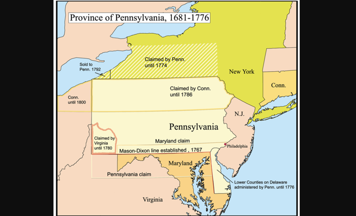
This map from 1774 shows Pennsylvania and illustrates a little-known land dispute between the Pennsylvania and Connecticut colonies that led to the Pennamite-Yankee wars. The hand-drawn map had belonged to the Independence Seaport Museum, which auctioned it off earlier in December. The Pennamite-Yankee wars took place around Wilkes-Barre in Northeastern Pennsylvania, a city founded by Connecticut settlers seeking to expand that colony's territory.
A hand-drawn map showing the colonial-era border dispute between Pennsylvania and Connecticut, two states that are today separated by roughly 100 miles of land belonging to New York, was sold at auction for $15,300 earlier this month.
The map previously owned by the Independence Seaport Museum was created around 1774, possibly by William Smith – an early provost of the University of Pennsylvania who helped the Penn family defend their claim to the Keystone State's modern territory.
It was found in the museum's archives several years ago, according to Chief Curator Craig Bruns. Independence Seaport Museum's board voted to sell the map because it didn't fit into the scope of the museum's collection, he said. The proceeds will be used to care for or expand their current library, which generally relies on items being donated.
Bruns said he hadn't been sure how much the map would get at auction, but was pleasantly surprised by the final sale price when it was sold at Bonhams auction house in New York on Dec. 15.
The winning bidder remains anonymous, but one of the contenders for the map was the American Philosophical Society. Patrick Spero, the organization's librarian, said it would have fit well into the society's large collection of other historical documents.
The map is a snapshot of the formative years of U.S. history, when the original 13 colonies jockeyed for land. Connecticuters would fight three bloody wars with Pennsylvania to expand their homeland's borders, or to just hold on to territory they believed was theirs.
The document shows what most people today would recognize as Pennsylvania, but it also illustrates the claim Yankee settlers from Connecticut made to the northern third of the state, beginning with area around Wilkes-Barre.
That's correct: Connecticut and Pennsylvania, two states that don't share a border, fought three wars over control of Wilkes-Barre?
"It's just crazy. Isn't it?" Bruns said. "(Connecticut) is so far away."
The short explanation for this, Spero said, is that early land charters for the two colonies overlapped.
Since the original borders for the 13 colonies were drawn up over the course of two centuries by Europeans with little knowledge of North America's terrain or the other existing charters, there were many conflicting land claims.
This led to armed territorial disputes up and down the East Coast from North Carolina to Massachusetts, Spero said.
"There's generally sort of a protectionist sentiment (between colonies and later states) that bubbles to the surface over land, money and trade," said Emma Hart, a professor of American history at the University of Pennsylvania.
The dispute between Connecticut and Pennsylvania was one of the bloodiest conflicts of this sort, Spero said.
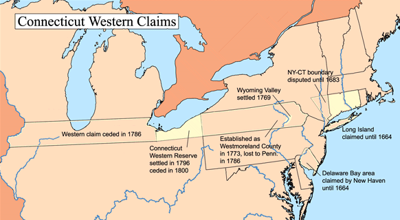
Connecticut claimed the entire northern third of Pennsylvania until 1786. Like many of the early British colonies in North America, Connecticut's earliest charter entitled the colony to all the land between its northern and southern borders, extending west all the way to the Pacific Ocean.
The Connecticut colony's earliest settlers had no idea how far that was, but that didn't keep their descendants from claiming land beyond the state's modern western border until as late as 1800.
Few of these claims were contiguous, as both New York and Pennsylvania were chartered immediately west of Connecticut.
By the second half of the 18th century, Spero said this had become a problem for Connecticut. The state's culture and economy were based around small, independent family farms, as was true throughout New England. With a rapidly growing population, Connecticut and the rest of New England were running out of land to subdivide.
In vast states like New York or Pennsylvania, settlers would simply move west. Even though the British tried in vain to keep Euro-American settlement on the east side of the Appalachian Mountains, thousands of settlers streamed into the backcountry to set up homesteads and fight with Native Americans.
But Connecticut had a finite amount of uncontested territory, and when its settlers moved further west seeking more land, they were relocating outside the boundaries of the colony. As a result, Connecticut's leaders were interested in staking claims to the western territories outlined in the colony's original charter in order to stop losing people to its western neighbors.
Connecticut's Susquehanna Company bought the land from the Iroquois Confederacy in 1754, but the tribe reneged on that agreement and sold the same land to the Penn family in 1768.
Still, in 1769 the Yankees moved to the Pennsylvania territory and founded Wilkes-Barre and four other towns. Pennsylvania's leaders responded by sending troops, and a confrontation ensued that came to be known as the First Pennamite-Yankee War. The Pennsylvanian forces failed, and the Yankee settlers in Wilkes-Barre remained.
The Yankees engaged in a distinctly New England pattern of settlement, which differed from the way other parts of the American frontier were populated by Europeans at the time.
Although New Englanders' lifestyle was just as rural and agrarian as settlers from any of the other of the 13 colonies, Spero said they were unique in that they anchored their farms in counties, towns and villages, whereas Pennsylvanian settlers set up isolated homesteads and fended for themselves.
He added that the Yankees were mostly of an English Puritan stock and had ancestors who arrived in the world generations ago, but the Pennamites were more ethnically and religiously diverse and tended to have more recent migrant ancestry.
One ethnic group did stand out in the Pennsylvanian military. The Scotch-Irish, or the descendants of the mostly ethnically Scottish and Presbyterian migrants who settled in modern-day Northern Ireland in the 17th century.
This group was well represented up and down the entire frontier at the time. Hart said they were "a people on the move who were used to living on the edge of society."
Still, Spero noted that elites from Philadelphia were the ones in charge of Pennsylvania's military. As was the case across the colonies, Hart said cooperation between coastal elites and the Scotch-Irish settlers in the backcountry was a marriage of convenience.
The elites had a disdain for what they saw as the backwards, clannish culture of these western settlers, who couldn't afford the safety and convenience of land closer to established population centers. But they desperately needed these settlers to fight for their interests on the western frontier.
King George III affirmed Connecticut's claim In 1771, and in 1773 more settlers came from there and founded Westmoreland in Northumberland counties. This led to the Second Pennamite-Yankee War in 1774, when the Yankees again successfully defended their land claims amid the growing tensions with Britain leading to the Revolutionary War.
Everyone knows who won that war, and by the 1780s the Continental Congress was the governing body in charge of the colonies, not the British Crown.
In 1782, the congress voted to rescind George III's ultimatum and returned the land to Pennsylvania. This was the only interstate conflict resolved by congress under the Articles of Confederation, which governed the union until the constitution was signed in 1788.
But this ruling led to a third conflict in 1784, when Pennamite forces again tried to evict the Yankees from their settlements.
Spero said the British Empire's failure to both keep settlers from staking out claims on the western frontier, which was technically illegal but exceedingly common, and administer a peaceful resolution to these conflicting claims are prime examples of how Britain failed to effectively govern its North American colonies in the run-up to the Revolutionary War.
"One of the greatest challenges that this new government had to deal with was this conflict between states," he said.
Tensions remained for years, but the conflict slowly fizzled out and by 1799, all the Yankee settlers had possession of their land and were officially recognized as Pennsylvania residents.
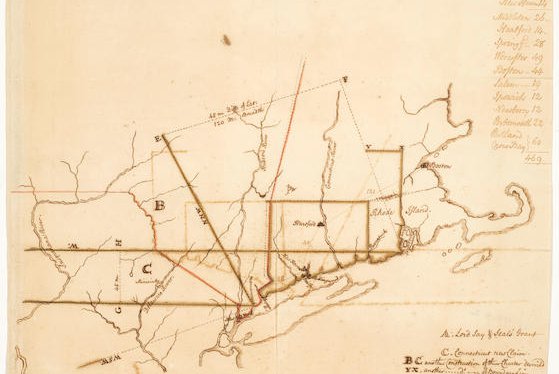
Hart said the hand-drawn map is emblematic of the sort of "wishful thinking" that defined colonial Euro-American cartography. Maps of this vintage depict the sort of control leaders wished they held over the landscape, not what land was actually under any colony's control.
Connecticut was not the only state Pennsylvania had territorial disputes with during the colonial era.
Maryland had claimed its northern border extended far enough north to include Philadelphia until 1767, when the Mason-Dixon line was surveyed to resolve the dispute.
It wasn't until 1780 that Virginia, which had not yet lost its northwestern counties, gave up its claim to the area around Pittsburgh.
Until the 1780s Pennsylvania claimed an enormous piece of present-day New York that extended from Syracuse to Buffalo. It also controlled what became Delaware until it broke off in 1776.
In 1792, Pennsylvania bought much of Erie County from New York, which gave the state access to the commerce taking place on the Great Lakes and completed its modern territory.
Although Connecticut gave up its claims in Pennsylvania in the 1780s, it continued to claim and send settlers to its Western Reserve – the part of Ohio around modern Cleveland, which extended from Lake Erie to the latitude of Connecticut's southernmost border with Westchester County, New York – until 1800.
That's when Connecticut finally accepted its fate as a small state on the U.S. Eastern Seaboard.
But that doesn't mean the Yankee settlers or their culture disappeared from Northeastern Pennsylvania. Spero said, "... If you travel there, it's going to feel a lot more like New York or New England than Lancaster," due to the "persistence of Yankee culture" in the region.