


April 01, 2018
 Kevin Shelly/PhillyVoice
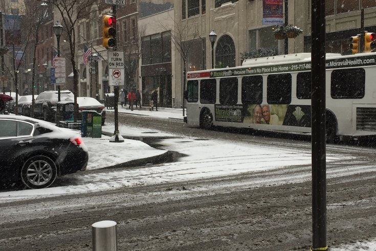
Snow falls in Center City Philadelphia on Saturday, Jan. 7, 2017.
Forecasters are boosting expected snow totals in some areas of the Philadelphia region as a late season coastal storm moves in overnight Monday.
A winter weather advisory is posted for the region from midnight to 1 p.m. Monday with potentially treacherous road conditions for the Monday morning commute.
As the quick-moving snowstorm moves from the mid-west to the Mid-Atlantic, a narrow swath of snow is expected north of the storm track, according to Accu-Weather. That swath of accumulating snow, at most, may be 100 miles wide, meaning a 50-mile shift in the storm track could mean the difference between several inches of snow, rain or no precipitation.
Rain or a rain/snow mix will develop overnight, changing to snow from northwest to southeast across the area between 1 and 4 a.m. north and west of I-95, and between 5 to 8 a.m. south and east of I-95. Sleet will mix in South Jersey and northern Delaware. Snow will be heavy at times between 4 and 8 a.m. with rates of 1-2 inches per hour. Accumulating snow ends from west to east between 9 and 11 a.m.
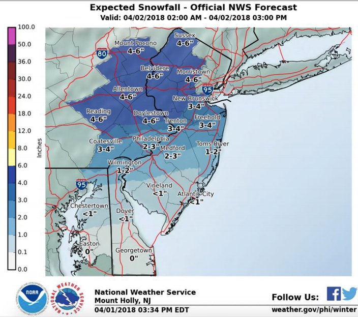
As much as a half-foot of wet snow could fall in the north and west suburbs of Philadelphia, including Pottstown, Pennsburg, Doylestown and Perkasie, according to the National Weather Service, the National Weather Service said.
From 3-4 inches of accumulation is expected in Coatesville and Lower Bucks County, with 2-3 inches most likely in Philadelphia and the westernmost parts of South Jersey, and less than an inch south and east, including the Jersey Shore.
How much snow accumulates on area roadways will depend on the snowfall rate. Rates at or greater than an inch per hour with temperatures near freezing will result in untreated roads becoming slushy to snow-covered, forecasters said.
The greatest travel impacts are expected where the higher snow totals are expected. Poor visibilities are possible, as well.
A small craft advisory is in effect for Monday due to wind gusts and rough seas on the coastal ocean waters of New Jersey and Delaware.
The snow won't be around for long.
With the sun emerging and high temperatures in the 40s on Monday afternoon, the snow will melt rapidly.
Here is the 7-day forecast for Philadelphia from the weather service:
Sunday night: Rain likely between 3 and 5 a.m., then rain and snow. Low around 33. West wind 5 to 8 mph becoming light and variable. Chance of precipitation is 80 percent. Total nighttime snow accumulation of around an inch possible.
Monday: Rain and snow before noon, then a chance of rain between noon and 2 p.m. High near 46. Northeast wind 6 to 9 mph. Chance of precipitation is 100 percent. New snow accumulation of 1 to 2 inches possible.
Monday night: A chance of rain after 3 a.m. Partly cloudy, with a low around 38. Calm wind becoming south around 5 mph after midnight. Chance of precipitation is 40 percent. New precipitation amounts of less than a tenth of an inch possible.
Tuesday: Rain likely, mainly after 9 a.m. Cloudy, with a high near 54. Southeast wind 6 to 8 mph. Chance of precipitation is 70 percent. New precipitation amounts between a tenth and quarter of an inch possible.
Tuesday night: Rain likely before 9 p.m. Mostly cloudy, with a low around 50. South wind 6 to 10 mph. Chance of precipitation is 60 percent. New precipitation amounts of less than a tenth of an inch possible.
Wednesday: Showers and possibly a thunderstorm, mainly after noon. High near 66. Chance of precipitation is 80 percent. New rainfall amounts between a quarter and half of an inch possible.
Wednesday night: Showers before 9 p.m. Low around 34. Chance of precipitation is 80 percent.
Thursday: Mostly sunny, with a high near 48.
Thursday night: Partly cloudy, with a low around 36.
Friday: Partly sunny, with a high near 56.
Friday night: A chance of showers. Mostly cloudy, with a low around 38. Chance of precipitation is 30 percent.
Saturday: A chance of rain. Mostly cloudy, with a high near 47. Chance of precipitation is 50 percent.
Saturday night: A chance of rain. Mostly cloudy, with a low around 32. Chance of precipitation is 50 percent.
Sunday: A chance of rain. Partly sunny, with a high near 46. Chance of precipitation is 30 percent.