


April 05, 2018
Winter is sounding like a broken record.
More precipitation – including the potential for some snow – is in the forecast for the weekend and beyond.
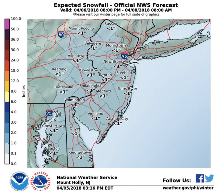
The primary concern is Friday night into Saturday, forecasters say, when a cold front will move through the area. A low pressure system will also be moving eastward to our south, creating precipitation over much of the Philadelphia region.
It looks like it could start as rain, but enough cold air likely will move in behind the front for snow to mix in. A changeover to all snow is possible in some places, according to the National Weather Service.
In parts of South Jersey, the precipitation could be sleet.
Either way, significant accumulations are not expected for now – about an inch or less.
Gusty winds are possible.
Sunday is expected to be dry, but forecasters said they are watching a potential storm for early next week.
There is the potential for a coastal low pressure system to move offshore of the Carolinas and move offshore of the Mid-Atlantic coast. Such movement could mean a period of precipitation for Monday through Tuesday.
And, yes, if enough cold air accompanies that storm, some places around the region could see some snow.
Meanwhile, the National Weather Service posted the highest recorded wind gusts from Wednesday.
The strongest gust recorded in the wider region was 75 mph at Batavia, New York. Closer to home, gusts of 60 mph were recorded in Fleetwood, Berks County, and Mount Pocono. A 56-mph gust was recorded in Newtown Square, Delaware County, and Pennsauken, Camden County, had one at 55 mph. The strongest gust recorded in Philadelphia was 49 mph.
Here is the 7-day forecast for Philadelphia from the weather service:
Thursday night: A chance of rain, mainly after 4 a.m. Increasing clouds, with a low around 35. West wind 6 to 11 mph becoming light and variable in the evening. Winds could gust as high as 21 mph. Chance of precipitation is 30 percent. New precipitation amounts of less than a tenth of an inch possible.
Friday: A chance of rain, mainly before 9 a.m. Cloudy, with a high near 64. Southeast wind 6 to 16 mph becoming southwest in the afternoon. Winds could gust as high as 26 mph. Chance of precipitation is 30 percent. New precipitation amounts of less than a tenth of an inch possible.
Friday night: Rain likely, mainly after 2 a.m. Cloudy, with a low around 37. Southwest wind 9 to 11 mph becoming northwest after midnight. Chance of precipitation is 60 percent. New precipitation amounts between a tenth and quarter of an inch possible.
Saturday: Rain and snow likely, mainly before 2 p.m. Cloudy, with a high near 40. North wind 8 to 10 mph. Chance of precipitation is 60 percent. New snow accumulation of less than one inch possible.
Saturday night: A chance of rain and snow before 8 p.m. Partly cloudy, with a low around 31. North wind 6 to 9 mph. Chance of precipitation is 30 percent. New snow accumulation of less than a half inch possible.
Sunday: Sunny, with a high near 46.
Sunday night: Partly cloudy, with a low around 31.
Monday: A chance of snow before 9 a.m., then a chance of rain and snow between 9 and 11 a.m., then a chance of rain thereafter. Mostly cloudy, with a high near 45. Chance of precipitation is 50 percent.
Monday night: Rain likely before 1 a.m., then rain and snow likely. Cloudy, with a low around 38. Chance of precipitation is 60 percent.
Tuesday: A chance of rain and snow before 9 a.m., then a chance of rain. Mostly cloudy, with a high near 52. Chance of precipitation is 40 percent.
Tuesday night: Mostly cloudy, with a low around 35.
Wednesday: Mostly sunny, with a high near 52.
Wednesday night: Mostly clear, with a low around 36.
Thursday: Mostly sunny, with a high near 59.