


September 04, 2016
Dangerous waves and rip currents caused by Tropical Storm Hermine mostly kept swimmers and surfers out of beach waters on Monday morning, the final day of a long holiday weekend.
Hermine continues to twist hundreds of miles off shore in the Atlantic Ocean as it moves away from South Jersey.
Whipping winds didn't keep some beach seekers from walking along the Jersey shore on Monday, but Labor Day vacationers quickly took to boardwalks as an aggressive high tide moved into the area late morning.
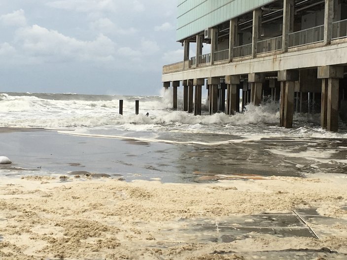
The waves eroded some of the shore, creating sand dune cliffs where kids climbed. Warnings of potentially dangerous riptides temporarily cleared the water Monday morning, but a couple of dozen beachgoers and a handful of surfers returned to the water in Atlantic City by the afternoon. A rougher surf cleared portions of the beachfront.
MD Mahabub Khan, 50, has worked as a taxi cart pusher at the shore for 27 years and said he still attracted some business over the weekend, but the smaller crowds were noticeable.
"People from New York and New Jersey are kind of stuck here (during bad weather), so they can still come," if forecasts don't play out as predicted, Khan said.
On Sunday night, Gov. Chris Christie warned visitors to the Jersey Shore to be careful, despite forecasts saying Hermine would not hit land.
"Don't be lulled by the nice weather," Christie said, referring to the sunny weather witnessed Sunday at many shore towns. "Don't think that nothing is going to happen, because something is going to happen."
Tropical storm-force winds remained possible Monday in New Jersey. Christie warned that minor to moderate flooding was still likely in coastal areas. He said the storm will cause major problems, even as it tracks away from land.
By mid-afternoon, the tropical storm's impact was being felt in New England, as it sat about 260 miles southeast of Nantucket, creating 20-foot waves and wind gusts of up to 50 mph. Similar gusts were expected across southern Rhode Island and southeastern Massachusetts.
New York City closed its beaches Monday because of rip currents. The ban could extend into Tuesday, depending on weather conditions, officials said.
Hermine was expected to stall over the water before weakening again.
"We're not looking at a landfall," said Dennis Feltgen of the National Hurricane Center on Sunday, adding Hermine is just sitting and pushing the water up along the coast, making the storm a great concern.
After a briefing with the National Weather Service at 6 p.m. Sunday, Christie ordered Island Beach State Park to reopen for Labor Day while Delaware Gov. Jack Martell lifted a limited state of emergency that he issued for Sussex County Saturday.
“I’m thankful that Tropical Storm Hermine has remained off the coast and its impact on our state has been minimal,” Governor Markell said in a news release.
Yet, parts of South Jersey remain in a state of emergency as Hermine lingers off shore, potentially bringing "life-threatening" storm surges to the Jersey Shore, according to the National Hurricane Center.
Hermine claimed three lives during its trail up the Atlantic seaboard. By late Monday, its position southeast of Nantucket created 20-foot waves and wind gusts of up to 50 kph about 55 miles southeast of the island. The storm was expected to stall over the water before weakening again.
On Saturday afternoon, New Jersey Gov. Chris Christie declared a state of emergency for Cape, Ocean and Atlantic counties after forecasters made revised predictions of the storm's impact, calling for the possibility of serious flooding.
I’ve declared a state of emergency for Ocean, Atlantic & Cape May Counties in preparation for Tropical Storm #Hermine.
— Governor Christie (@GovChristie) September 3, 2016
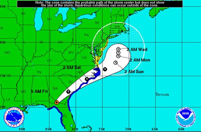
By Sunday morning, the National Hurricane Center warned of a dangerous storm surge that will continue along the Atlantic coast from Virginia to New Jersey, potentially for several days.
Danger of life-threatening inundation next 36 hrs from Chincoteague, Va. to Sandy Hook, N.J. https://t.co/RFueMSM1Xn pic.twitter.com/rTNsYJfQHn
— NHC Atlantic Ops (@NHC_Atlantic) September 4, 2016
At 11 a.m. Sunday, Hermine's top sustained winds reached 70 mph (110 kph) as it moved east-northeast at 10 mph (17 kph). She was centered about 301 miles (500 kilometers) east-southeast of Ocean City, Maryland.
The storm, which made landfall in Florida early Friday as a hurricane and weakened to a tropical storm, could follow a number of paths over the next few days, producing hazardous conditions well into the coming week.
While New Jersey remained in a state of emergency Sunday, Christie said during a press conference that residents and visitors should remain cautious despite seemingly clear skies.
"...even though the weather is really nice outside at the moment and is nice at many parts of the Jersey Shore right now, we urge people to be careful," he said.
"This is certainly not Sandy," Christie later said, referring to the 2012 storm that destroyed or damaged close to 350,000 homes in New Jersey. Though, he warned that the winds remain a concern.
Key messages from NHC for Tropical Storm #Hermine issued at 5am EDT Sunday. https://t.co/tW4KeGdBFb @NHCDirector pic.twitter.com/ciutgnWQGQ
— NHC Atlantic Ops (@NHC_Atlantic) September 4, 2016
"The slow motion and large wind field associated with Hermine will result in a long duration of hazardous conditions along much of the mid-Atlantic coast extending into southern New England through the holiday weekend and into mid-week," said NHC Hurricane Specialist Michael Brennan.
Waves crash near the Playground Pier at Caesars Casino in Atlantic City on Saturday, Sept. 3, 2016. Heavy rains and winds are expected to hit the Jersey Shore over Labor Day Weekend as Tropical Storm Hermine works its way up the East Coast.
The severity of the impact will be determined by the track and strength of the storm, which remains a bit up in the air.
However, the threat of the storm has already forced some event cancellations, including two beach concerts in Atlantic City.
Ocean City has closed all beaches to swimming, and while no evacuation has been put in place, residents and visitors are encouraged to go inland until the storm passes as heavy street flooding is expected.
Brigantine residents who were affected by Hurricane Sandy and Winter Storm Jonas are being asked to voluntarily evacuate, while non-residents of Stone Harbor are also being asked to leave. Officials in Rehoboth Beach also announced on the city's Facebook page that beaches are closed for swimming and foot traffic.
.
So, what can folks celebrating the Labor Day weekend at the shore expect?
• Dangerously rough surf during the entire holiday weekend and possibly into the middle of next week. The risk of rip currents is moderate to high through Monday and possibly Tuesday.
• The potential for minor to moderate coastal flooding around the times of high tide from late Saturday onward. Major flooding in some local areas remains a possibility, especially in the back bays where water accumulates with each successive high tide. The severity, again, will depend on the storm's path and intensity.
• Tropical storm force winds (39 mph or greater sustained) are possible for much of the region, but the highest chance is along the Jersey Shore and Delaware beaches, from Sunday into Sunday night. Even with an offshore track, gusts of 30 to 35 mph are expected along the coast.
• Tidal flooding up the Delaware Bay and Delaware River is possible. Little to no flooding impact is expected in Southeastern Pennsylvania, Delaware and across New Jersey.
• Folks going out to the Made in America music festival on the Benjamin Franklin Parkway will see a slight chance of rain on Saturday and only a bit higher percentage of precipitation for Sunday.
• The potential for wind gusts is much weaker than along the coast.
Here are the holiday weekend forecasts for Philadelphia, the Jersey Shore and the Poconos:
PHILADELPHIA
Sunday: A chance of rain. Cloudy, with a high near 79. Breezy, with a north wind 16 to 21 mph. Chance of precipitation is 30 percent. New precipitation amounts between a quarter and half of an inch possible.
Sunday Night: A chance of rain. Cloudy, with a low around 65. Breezy. Chance of precipitation is 30 percent. New precipitation amounts between a tenth and quarter of an inch possible.
Labor Day: Tropical storm conditions possible. Mostly cloudy, with a high near 79.
Monday Night: Tropical storm conditions possible. Mostly cloudy, with a low around 66.
Tuesday: Mostly sunny, with a high near 86.
JERSEY SHORE
Sunday: Tropical storm conditions possible. Rain likely. Cloudy, with a high near 74. Chance of precipitation is 60 percent. New precipitation amounts between 1 and 2 inches possible.
Sunday Night: Tropical storm conditions possible. Rain likely. Cloudy, with a low around 68. Chance of precipitation is 60 percent. New precipitation amounts between three-quarters and 1 inch possible.
Labor Day: Tropical storm conditions possible. A chance of rain. Mostly cloudy, with a high near 78. Chance of precipitation is 30 percent.
Monday Night: Tropical storm conditions possible. A chance of rain. Mostly cloudy, with a low around 68. Chance of precipitation is 30 percent.
Tuesday: Tropical storm conditions possible. Partly sunny, with a high near 83.
POCONOS
Sunday: A slight chance of rain. Cloudy, with a high near 73. Northeast wind 9 to 13 mph. Chance of precipitation is 20 percent.
Sunday Night: A chance of rain. Cloudy, with a low around 56. Chance of precipitation is 30 percent. New precipitation amounts of less than a tenth of an inch possible.
Labor Day: Mostly cloudy, with a high near 73.
Monday Night: Mostly cloudy, with a low around 57.
Tuesday: Mostly sunny, with a high near 79.
Information from the Associated Press was used in this report.