May 15, 2018
 Staff/PhillyVoice
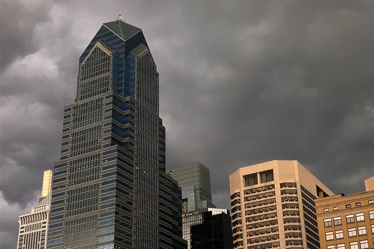
Storm clouds darken the Center City Philadelphia skyline late Tuesday afternoon. Severe weather was expected in parts of the region.
Tuesday night’s storm truly ripped through the Northeast region.
Swirling dark clouds rolled into Philly around rush hour, the wind picked up and ominous skies all pointed toward some bad rain on the way – which eventually began just after 6:15 p.m.
At 7:35 p.m., PECO reported about 9,700 customers without power, with the vast majority in Montgomery and Bucks counties.
In New Jersey, PSE&G reported more than 40,000 customers without electricity, mostly in the central and northern part of the state. Nearly 1,500 Atlantic City Electric customers were without power as well.
Flights on average at Philadelphia International Airport were being delayed 2 hours and 14 minutes, according to the FAA, which also reported similar delays at Newark, JFK and LaGuardia airports.
The National Weather Service is calling for significant, severe weather threats tonight in southern New England and the northern Mid-Atlantic. Any real damage will wrap up Tuesday night in our area — and in northern New England some flash-flooding could continue into Wednesday.
But this rain could linger for the next few days.
In places like D.C. (which was hit the hardest last night), New York, Connecticut and New Jersey, authorities are dealing with the aftermath like traffic, flooding and wind damage.
Here are some images of the storm that have been posted to social media in the Philadelphia region and beyond.
Current #wx scene in Burlington Township, NJ. #NJwx @NWS_MountHolly @GarySzatkowski @nynjpaweather @MikeMasco #NJwx pic.twitter.com/W2U8wbQu2o
— Burlington NJ Wx (@BurlingtonNJWx) May 15, 2018
Storms moving into Philly a few minutes ago #pawx pic.twitter.com/vO6LLJmTf4
— Dave Skutnik (@DaveSkutnik) May 15, 2018
Just a cool @Apple #iPhone #timelapse from the #storm @NBCPhiladelphia pic.twitter.com/IUGIlcvab9
— Anthony Ioime (@anthonyioime) May 15, 2018
Looks like rain...any moment now... pic.twitter.com/Jz3TpOMPyR
— Diana Lu (@dianaluwho) May 15, 2018
All trains canceled for Metro North. Sweet lord. #MTA #metronorth pic.twitter.com/gxfn6FfKhw
— Barb Leung (@barb_leung) May 15, 2018
@katebilo @CBSPhilly here is comes in Lower Providence pic.twitter.com/vQIpuonH2f
— Eric Gronwaldt (@gronwaldt) May 15, 2018
@epawawx @NBCPhiladelphia Royersford, PA before the storm hits... pic.twitter.com/01KOYpGLWw
— Lisa Bonnes (@LDBonnes) May 15, 2018
Tornado warned storm in Allentown PA today pic.twitter.com/py5jJFO5cS
— Ray Leichner ⚡️⛈🌪 (@stormchaserray) May 15, 2018
Storm clouds rolling over the Center City skyline. Winds are picking up in Philadelphia- storms should be hitting the city by 6:30PM pic.twitter.com/kFGpKohtgs
— Cecily Tynan (@CecilyTynan) May 15, 2018
Mob scene at Grand Central right now, no trains departing because of the storm! WOW pic.twitter.com/af2LDq891B
— calinka005 (@Calinka005) May 15, 2018
Incredible #stormdamage in #caldwell #nj and @kristendahlgrennbc will have a complete wrap up and I’ll talk what’s next #tonight on @nbcnightlynews pic.twitter.com/Bei0QghJ6B
— Al Roker (@alroker) May 15, 2018
The most insane storm I’ve seen in CT. #CTwx pic.twitter.com/9ZzU1zLeMp
— Andrew Janes (@JanesWx) May 15, 2018
Crazy shot of Hartford skyline with storm. @FOX61News pic.twitter.com/SVnNQwaTLR
— Jenn Bernstein (@JennBNews) May 15, 2018
And then there’s this terrifying time lapse of the New York City skyline.
Stunning timelapse shows storm enveloping Manhattan as severe thunderstorms threaten to bring flash flooding, winds, hail and even possible tornadoes across the Northeast. https://t.co/nHKi3jOu5Y pic.twitter.com/z4CArJhs1I
— World News Tonight (@ABCWorldNews) May 15, 2018
Storm clouds over Manhattan. pic.twitter.com/mDeev6Ljkj
— Rhonda Schaffler (@SchafflerNJTV) May 15, 2018
This is a developing story. Check back for more updates.