May 11, 2026
 Provided Image/Philadelphia Office of Emergency Management
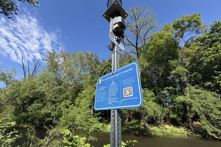
A flood gauge monitoring system located at Pennypack Creek in the Holmesburg section of Northeast Philly.
When Tropical Storm Isaias swept the region in 2020, millions of dollars in damages were reported in some of Philadelphia’s lowest-lying neighborhoods. Now, those same residents have been equipped with a tool to prepare for upcoming storms.
Officials with the city’s Office of Emergency Management activated gauges and cameras around flood-prone neighborhoods like Eastwick, Manayunk and areas of Northeast Philadelphia on Saturday as part of a pilot program to bolster the areas’ climate resilience. Residents can access the data and receive notifications about significant changes online and on mobile devices.
MORE: New York Bagel Bakery in Overbrook Park damaged by another gas explosion
The website, available at flood-monitoring.phila.gov, regularly updates measurements of water temperature, water levels and barometric pressure, which is the weight of air molecules above the Earth’s surface.
Real-time monitoring is available at nine locations across the city through a mix of gauges and live traffic cameras. Users can either choose a location on the website’s map or type in an address to find the most up-to-date information for that area. Guides on flood insurance, preparing for potential flood conditions and dealing with the aftermath of a storm are also available on the site.
Gauges are currently operational in the following areas:
• Darby Creek
• Cobbs Creek
• Pennypack Creek
• Manayunk Canal
• Heinz Wildlife Refuge
• Saturn Place
• Venice Island
Cameras have been installed at the following intersections:
• 80th and Caesar
• 78th and Buist
• 77th and Elmwood
• Cobbs Creek and Springfield
• Kelly Drive and Midvale Avenue
• Bayton Street and Church Lane
• Godfrey Avenue and Beechwood Street
The project was funded through a $335,000 grant awarded by Philadelphia's Office of the Chief Administrative Officer that was also used to expand the number of languages ReadyPhiladelphia safety alerts are available in, according to Jeffrey Kolakowski, communications director with the Office of Emergency Management.
The database is also part of a larger Eastwick Flood Resilience Strategy, which aims to build a long-term mitigation plan as climate change models project the area to get wetter and hotter.
The 82-page plan, published in March, is the result of a two-year collaborative process between the city and residents of the neighborhood in Southwest Philadelphia near the Cobbs Creek and Darby Creek watersheds.
“Listening to residents, addressing their concerns and incorporating their ideas into potential solutions is critical to creating safer and stronger communities,” Dominick Mireles, deputy managing director for community safety, said in a statement.
Recommendations include installing a wetland park to control excessive runoff after a storm, relocating residents in some of the more vulnerable areas and elevating 84th Street and Hook Road to provide residents around the busy “Planet Streets” with a safe evacuation route.
Following back-to-back tropical storms in 2020 and 2021 that inundated the streets with several feet of water and damaged hundreds of homes, officials launched the Eastwick Near-Term Flood Barrier Project which will install temporary flood barriers using a $1.38 million federal grant. A 15-foot levee around Cobbs Creek has been under evaluation by the U.S. Army Corps for around two years.
Despite being located on a federally designated floodplain, the Federal Emergency Management Agency did not list the neighborhood as a Community Disaster Resilience Zone until 2023, which opens up more opportunities for federal funding grants.
Correction: This story was changed to reflect that the planned Eastwick Near-Term Flood Barrier Project calls for the use of temporary flood barriers and that the levee around Cobbs Creek is under evaluation by the U.S. Army Corps. It also has been changed to note recommendations to elevate 84th Street and Hook Road.