March 07, 2018
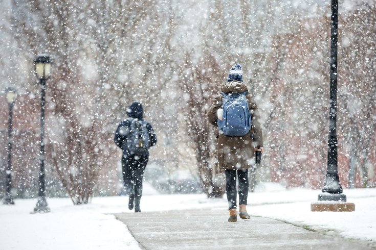 Thom Carroll/PhillyVoice
Students walk through Drexel Park in University City as heavy snow falls in the morning on Wednesday, March 7, 2018.
After a sluggish start, Wednesday's nor'easter had finally brought a steady snowfall across the Philadelphia region by lunchtime and looked on pace to bring at least 8 inches of snow to the area by nightfall.
The heavy, wet flakes, expected to create near-whiteout conditions in the city and suburbs at times during the day, are here.
But thundersnow? Nah, didn't see that coming.
Anyone else just hear the #Thundersnow in Philly? pic.twitter.com/JlC24aJ2dC
— Jack Inacker (@JackInacker) March 7, 2018
This is the loudest #thundersnow I've ever heard!!! cc @LaurieStenger10 #Philly
— Raj (@ClearHeatVision) March 7, 2018
Yup, that was #thundersnow
— Philly City Girl (@citygirl_philly) March 7, 2018
#thundersnow is in full force in South Jersey @JimCantore
— Philly Special K (@KevinIsOpen711) March 7, 2018
Reports of the rare weather phenomenon from people along the I-95 corridor and in Philly and New York City began popping up on social media late Wednesday morning and were trending locally by the afternoon.
Here's a sampling of the reaction:
@nynjpaweather @NWS_MountHolly thundersnow near Horsham, PA. Snow is coming down fast pic.twitter.com/jEacDWKWmg
— Dan Cook (@diabetic022) March 7, 2018
First time I've ever heard it. Thunder snow here in Columbus, NJ @nynjpaweather @GarySzatkowski
— Steven Schnaudt (@sschnaudt) March 7, 2018
#thundersnow in Bucks County #fox29snow @FOX29philly pic.twitter.com/BZ2x4sEoDu
— Megan Wilcke (@MeganWilcke) March 7, 2018
Just experienced #THUNDERSNOW for the first time of my life and let me tell you it is everything I thought it could be.
— PatriotsOnTS (@PatriotsOnTS) March 7, 2018
just heard #thundersnow! the best part is the kids from the middle school across the street from the ANHD office screaming their heads off in excitement, which i can't do at my desk
— Lena Afridi (@lpafridi) March 7, 2018
I wish I was as excited about life as @JimCantore is about #thundersnow also, Philly just had some so where are you Jim? pic.twitter.com/8gxFnVFJMW
— Tori G (@Ms_Tori_G) March 7, 2018
Finally just heard the 1st rumble of #thundersnow here in the far NE Philly! Weird!
— Cuba Rodriguez (@Cuba_was_here) March 7, 2018
Its dumping big fat flakes and now #thundersnow in Philly #NorEaster2018. Kaboom! Did you hear that @JimCantore ?!?!
— Leslie Benoliel (@lhbenoliel) March 7, 2018
#thundersnow heard hear outside Philly around 12:50 p.m !⚡️🌨
— Robert Zwerling (@zwerob) March 7, 2018
Meteorologists said earlier Wednesday morning that thundersnow would be a possibility.
As The Washington Post explains, thundersnow typically develops in quickly spinning nor'easters.
Per the report:
Wednesday’s scenario is unique because the air at the mid-levels is so incredibly cold. That will enable the generation of “traditional” vertical instability, just like in the summertime. The result could be a spectacular — and unusual — light show in major metropolitan areas of the Northeast during the height of the storm. The National Weather Service Storm Prediction Center has included many Northeast cities in their thunderstorm outlook, a highly atypical move in the wintertime.Forecasters are calling for snowfall rates of 1-2 inches per hour to continue this afternoon.