


April 29, 2016
 City Observatory/Source
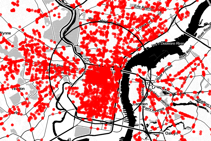
This map shows where certain types of storefront businesses are concentrated in Philadelphia.
When you stroll down Federal Street in Point Breeze, or along Frankford Avenue in Fishtown, or down Poplar Street in Brewerytown, how likely are you to be frequently greeted by bars, eateries and shops?
City Observatory has an answer. A recent report from researchers at the think tank used data from the U.S. Business Database to plot out clusters of storefront businesses in a number of large metropolitan areas in the country.
Dubbed the Storefront Index, it found where businesses that serve consumers' everyday needs are concentrated close together. The researchers mapped out a number of types of businesses – grocery and hardware stores, beauty salons, bookstores, bars, restaurants and more — but only included those within 100 meters of another storefront business.
The study excluded some types of services (finance and health care) as well as businesses engaged primarily in business-to-business, manufacturing and wholesale activities. This was done to focus on stores that "any person might walk into to buy something."
Taking a glance at Philly, some obvious things stick out right away: a large concentration of neighboring businesses in Center City, clusters along major thoroughfares like Broad, Girard and Snyder, and fewer storefronts as you branch out to the corners of the city. You can check out City Observatory's interactive map below:
PlanPhilly notes this information can be useful in assessing the economic health of a neighborhood:
Neighborhood businesses depend on foot traffic, and some studies have found that the number of businesses per acre is the most important predictor of whether people are likely to walk in their neighborhoods.
Places with clusters of storefronts are also likely to have stronger residential real estate markets, as walkable urban neighborhoods are at a premium nationally. Metrics like Walk Score have become one of the factors people consider when choosing a neighborhood, and the scores are mostly determined by the volume of amenities within walking distance.
City Observatory's report (available in full here) came to similar conclusions, with the researchers adding that by providing consumer choices in close proximity to city residents, you reduce travel demand and, therefore, greenhouse gasses.