


February 08, 2016
 Matt Rourke/AP
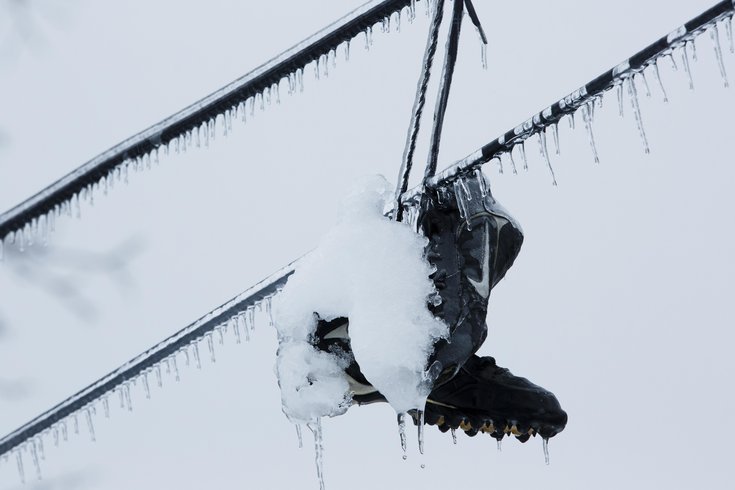
Ice and snow covers sneakers hanging from utility lines after a winter storm in Philadelphia.
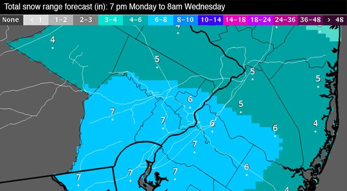
A Monday night storm could drop as many as 7 inches of snow on some parts of the Philadelphia region.
The National Weather Service in Mount Holly has issued a winter storm watch from midnight through late Tuesday night for far southeastern Pennsylvania, South Jersey and northern Delaware.
The snow, expected to begin light and intermittent on Monday night, may become moderate or heavy, especially south and west of the Philadelphia, probably Tuesday. Total accumulation of 4-7 inches of snow is expected, forecasters said. Rain may mix in closer to the Jersey coast, reducing snowfall totals there.
Late Monday afternoon, forecasters on Monday lowered the overall expected accumulation by an inch, to 7, but boosted the amount of snowfall expected in the city and its suburbs to the north and west.
The snow may make traveling more difficult for both the Tuesday morning and evening rush hour commutes.
Winds will be out of the northeast at 10-15 mph with gusts to 20 mph late Monday night into Tuesday. Temperatures will drop into the high 20s tonight, then rise back into the 30s on Tuesday.
A Code Blue alert goes into effect at 6 p.m. in Philadelphia and Camden County. People are asked to call @ProjectHOME at 215-232-1984 if you see a person in need of shelter in the city.
Persons seeking shelter in a warming center in Camden County should contact their local municipality. Additional resources are available by calling the county Department of Health and Human Services at (800) 999-9045, or by visiting www.camdencounty.com
Philadelphia officials have already canceled trash and recycling pickup for Tuesday since trash trucks will be plowing. Residents are asked to hold Tuesday's trash until the following week.
Forecasters also have a close eye on a clipper system that could bring snow to the area late Friday. Some weather models are indicating that a wave of low pressure may remain too far offshore to be a factor, but another model is predicting a deeper, more northerly system that could result in snow.
In any event, a shot of arctic air will mean temperatures 15-20 degrees below normal next weekend.
Here's the forecast through the rest of the work week from the weather service:
Monday night
Snow, mainly after 1am. Low around 29. Northeast wind 6 to 14 mph. Chance of precipitation is 80 percent. New snow accumulation of 1 to 2 inches possible.
Tuesday
Snow. High near 36. Northeast wind 10 to 15 mph becoming light in the afternoon. Chance of precipitation is 80 percent. New snow accumulation of 1 to 2 inches possible.
Tuesday Night
Snow likely, mainly before 1am. Cloudy, with a low around 30. Calm wind becoming west around 5 mph after midnight. Chance of precipitation is 70 percent. New snow accumulation of 1 to 3 inches possible.
Wednesday
A chance of snow showers before 9am. Mostly cloudy, with a high near 37. West wind 8 to 13 mph. Chance of precipitation is 30 percent. Little or no snow accumulation expected.
Wednesday Night
Mostly cloudy, with a low around 25.
Thursday
Partly sunny, with a high near 34.
Thursday Night
Mostly clear, with a low around 17.
Friday
Mostly sunny, with a high near 31.
Friday Night
Partly cloudy, with a low around 19.