
March 03, 2019
 Thom Carroll, File/PhillyVoice
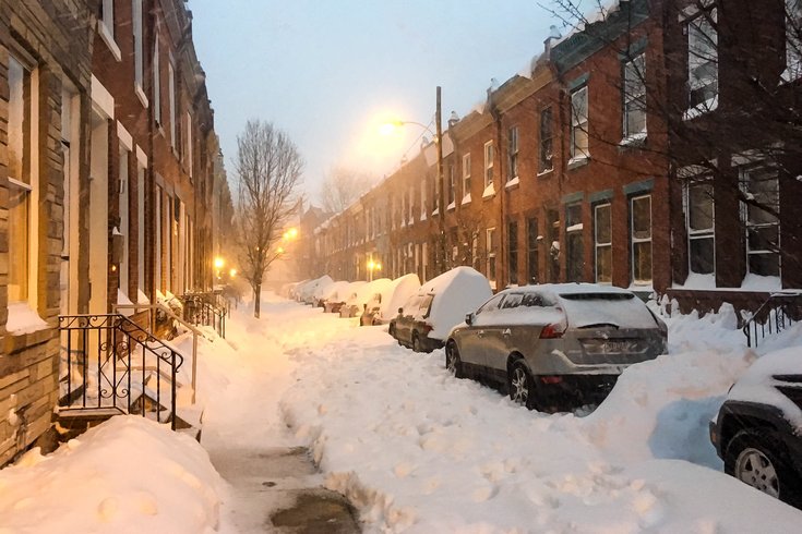
Snow clogs the streets on North Bucknell Street in the Fairmount section of Philadelphia in this file photo.
Winter Storm Scott is on its way - and soon. That much we know.
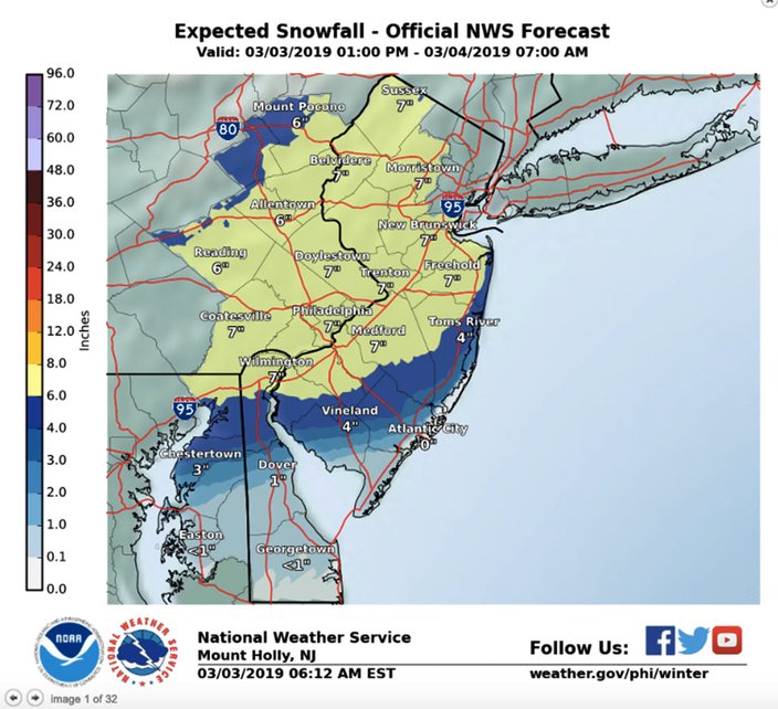
Whether this significant weather system dumps 5-8 inches of snow across the region or somewhat less is not as certain. Forecasters agree this one has been difficult to pinpoint. The precipitation is a given; the track of the storm and where temperatures will be on the side of freezing less so.
Some see more accumulation of snow; some less.
So with a winter storm warning in effect from 3 p.m. Sunday to 7 a.m. Monday, here's what you may expect over the next 18 hours:
Rain has already reached Wilmington and is edging toward Philadelphia and start soon, if it hasn't already reached the southern parts of the region by 2:30 p.m. The precipitation will remain rain until about sunset and then transition to heavy wet snow.
The snow is heaviest during this period in the Philadelphia region, according to the National Weather Service. In southern Delaware, rain and sleet are expected. The sleet moves to the north into parts of central Delaware and South Jersey during this period with a bit warmer air seeping in.
The sleet mix is forecast to reach I-95 corridor before midnight, with parts of the Jersey Shore changing to all rain. The system passes off the Virginia coast around 11 p.m. and the wind in our region should back from the northeast to the north, forecasters said. The northwest progress of the milder air should come halt and reverse shortly after midnight. Precipitation rates will be on the decrease, but any sleet and rain is expected to change back to light snow before ending late Sunday night.
The snow (sleet? rain?) ends between 3 and 5 a.m.
The Monday morning commute could be hazardous, and moreso, especially if you live north and west of the city. The snow, sleet and rain will likely have ended, but road conditions are likely to remain slick and dangerous in many locations.
Here is the 7-day weather service forecast for Philadelphia:
Sunday afternoon: Rain before 5 p.m., then rain and snow. High near 43. Calm wind. Chance of precipitation is 90 percent. Total daytime snow accumulation of 1 to 3 inches possible.
Sunday night: Rain and snow before midnight, then snow, possibly mixed with sleet between till 2 a.m., then snow likely afterwards. Low around 32. Light and variable wind becoming north 5 to 9 mph in the evening. Chance of precipitation is 100 percent. New snow and sleet accumulation of 3 to 7 inches possible.
Monday: Cloudy, then gradually becoming mostly sunny, with a high near 36. Northwest wind 9 to 14 mph.
Monday night: Mostly clear, with a low around 15. West wind 6 to 10 mph.
Tuesday: Sunny, with a high near 31. West wind 6 to 9 mph.
Tuesday night: Partly cloudy, with a low around 15.
Wednesday: Mostly sunny, with a high near 27. Blustery.
Wednesday night: Partly cloudy, with a low around 11.
Thursday: Sunny, with a high near 32.
Thursday night: Partly cloudy, with a low around 19.
Friday: Mostly cloudy, with a high near 36.
Friday night: A chance of snow. Mostly cloudy, with a low around 26. Chance of precipitation is 30 percent.
Saturday: A chance of rain and snow. Mostly cloudy, with a high near 43. Chance of precipitation is 30 percent.